PRINTER FRIENDLY PDF
EPUB
AUDIOBOOK
Abstract: The scale of U.S. casualties during Operation Galvanic has made the operation controversial, yet losses would likely have been far worse if not for the U.S. Fifth Amphibious Force’s successful efforts to mitigate littoral obstacles. The seizure of the Gilbert Islands demonstrated that by exploiting effective intelligence to take calculated risks, even the most complex and well-developed littoral defenses could be defeated. Unable to select a different objective or to secure additional forces, Rear Admiral Richmond Kelly Turner instead exploited Joint force intelligence, surveillance, and reconnaissance (ISR) to find the weakest parts of the Japanese defenses.
Keywords: Operation Galvanic, Gilbert Islands, World War II, V Amphibious Corps, Fifth Amphibious Force, Tarawa Atoll, Betio Island
Introduction
In the aftermath of the battle for Tarawa, the commander of the V Amphibious Corps remarked that “it looks beyond the realm of a human being that this place could have been taken. These Japanese were masters of defensive construction.”1 The Japanese defenses on Betio, Tarawa’s largest island, have been described as “a more sophisticated series of defensive positions [than] on any subsequent island until [U.S. forces] reached Iwo Jima in 1945” and as “yard for yard . . . the toughest fortified position the Marines would ever face.”2 Despite the scale of the Japanese defensive preparations, in 1943 U.S. forces not only selected Betio as an objective but succeeded in seizing it alongside other objectives in the Gilbert Islands chain. Eighty years later, seizing a defended beach protected by obstacles offshore, at the waterline, and inland appears so difficult that commanders would be unlikely to select such objectives. Modern commanders and planners, just like those in 1943, may have no other choice. The Gilbert Islands were not the preferred objective in 1943; however, strategic aims and competing operational needs made their capture a requirement.3
The scale of U.S. casualties during Operation Galvanic has made the operation controversial, yet losses would likely have been far worse if not for the U.S. Navy’s Fifth Amphibious Force’s successful efforts to mitigate littoral obstacles. Contrary to claims that the “intelligence must have been faulty,” the seizure of the Gilbert Islands demonstrated that by exploiting effective intelligence to take calculated risks, even the most complex and well-developed littoral defenses could be defeated (albeit still at high cost).4 Rear Admiral Richmond Kelly Turner’s use of the call sign “ANZAC,” a reference to the failed amphibious assault at Gallipoli in 1915, suggests that he was well aware of the risks he was accepting.5 Unable to select a different objective or to secure additional forces, he instead exploited Joint force intelligence, surveillance, and reconnaissance (ISR) to find the weakest parts of the Japanese defenses.
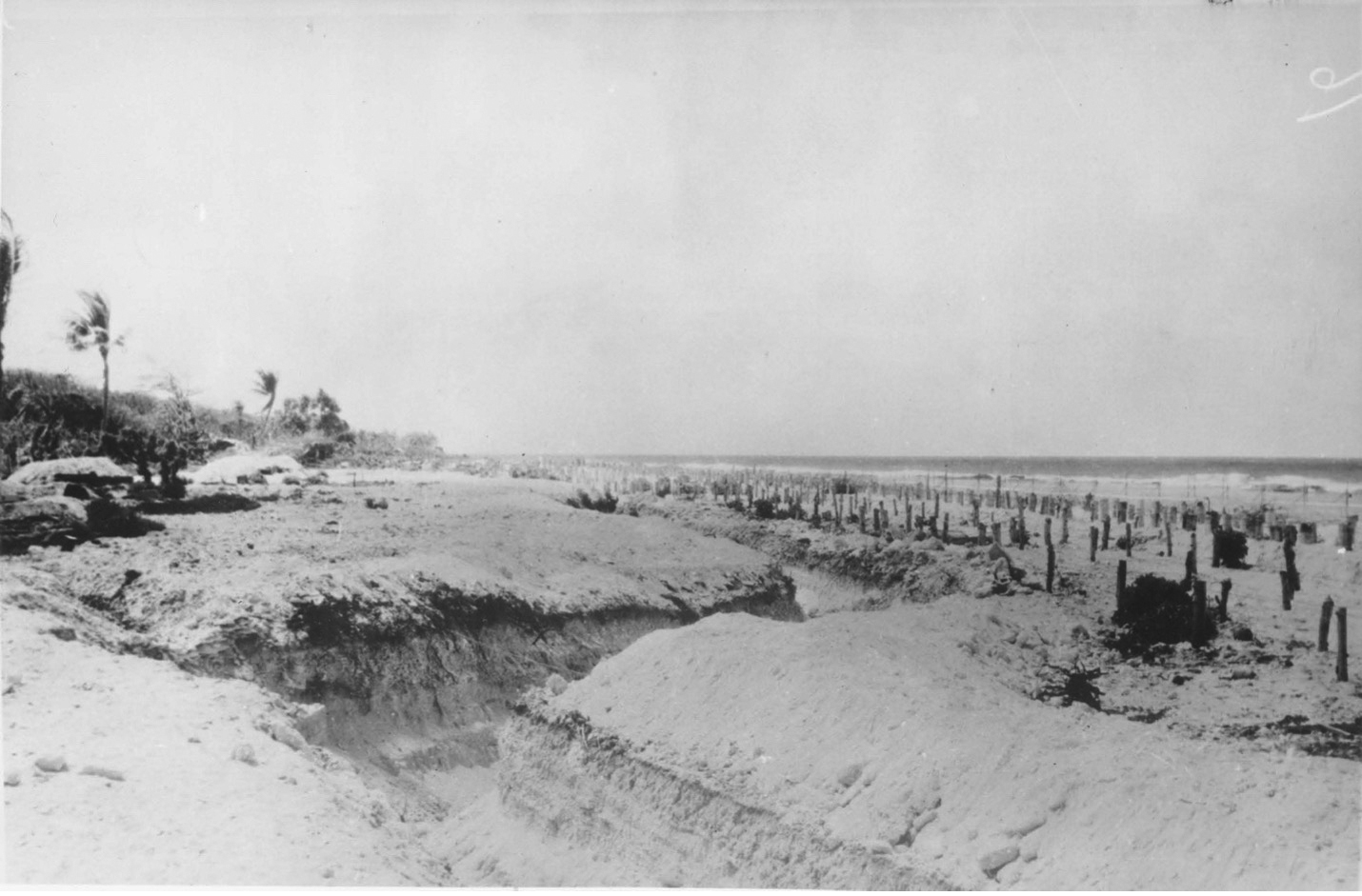
Japanese antitank and antilanding obstacles at Tarawa demonstrate the complexity of the defensive preparations. Unknown Japanese officer, “Photographs (Believed to Have Been Taken From Japanese Officer, KIA), 1943,” 1943, Gilbert Islands Collection, COLL 3653, box 5 Gilberts: Tarawa, 1943–1944, folder 2, Archives Branch, MCHD, Quantico, VA, 29
The well-resourced defenses at Tarawa and the less-prepared positions at Makin Island are representative of the challenging littoral obstacles that commanders may again face today. As the selection of the Gilbert Islands as an objective highlights, simply choosing to avoid prepared defenses may not always be a viable option. While ISR is unlikely to entirely mitigate the risks posed by littoral obstacles, it can make these risks tolerable. If littoral forces must seize beaches protected by complex obstacles again in the future, Operation Galvanic suggests that the employment of Joint ISR to find gaps that combined arms teams can exploit is a model for success.
An Unavoidable Objective
Considered in isolation, the remote Gilbert Islands appear an unlikely operational objective during a global war. While the tiny atolls offered military advantages, these were hardly decisive. Operation Galvanic was less about the value of the Gilbert Islands than about the need to maintain pressure on Japan while constrained by competing interests in other theaters. The United States and Great Britain held differing strategic views regarding the Pacific. U.S. leaders argued that “having seized the initiative from Japan the previous August at Guadalcanal, it would be unwise to relinquish it and allow the Japanese to dig in too strongly or to mount a counteroffensive.”6 In contrast, the British cautioned against the diversion of resources from the agreed “Germany first” strategy.7 In January 1943, Admiral Ernest J. King, the U.S. Chief of Naval Operations, convinced the Allied Combined Chiefs of Staff that an additional campaign in the Pacific was required “to push the war against Japan by maintaining unremitting pressure against her from every direction.”8 To reach a compromise, King suggested that operations in the Central Pacific would only be conducted “with the resources available in the theater.”9 While this concession enabled the American staff to secure British support, it would impose significant time and resource constraints on Operation Galvanic.
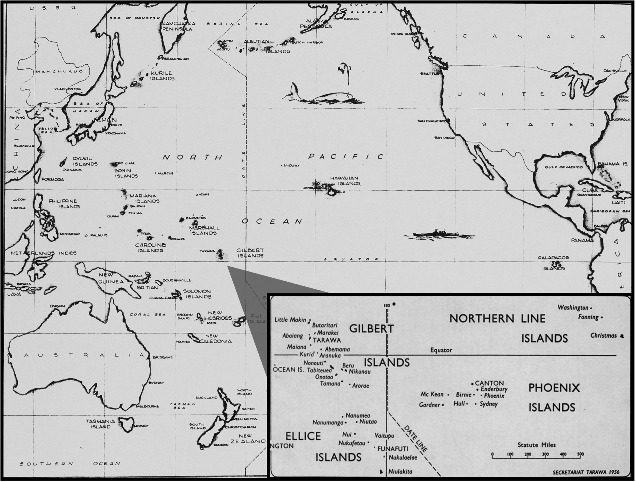
Map showing the location of the Gilbert Islands. The base map was drawn by CM1 Larry E. Klatt, a Navy Seabee who landed at Tarawa as part of the 18th Marine Regiment, 2d Marine Division. Larry E. Klatt, “Drawing 18,” Larry Klatt Papers, COLL 2173, Archives Branch, MCHD, Quantico, VA); and inset, “Kiribati, The Gilbert and Ellice Islands Colony, 1956,” Secretariat of the Pacific Community and Government of Kiribati, Tarawa, 1956
The U.S. Joint Chiefs of Staff directed Admiral Chester W. Nimitz, commander of the Pacific Ocean Areas theater, to develop a Central Pacific offensive. As the concept took shape, planning remained heavily influenced by War Plan Orange, which “though it had been officially discarded, survived like a ghostly shadow in the thinking of most senior Navy officers, including King and Nimitz.”10 Given that War Plan Orange had focused on the Marshall and Caroline Islands, the early guidance issued by the Joint Staff “ignored the Gilberts and identified the Marshalls as the initial target.”11 As planning continued, it became increasingly clear that these initial objectives were beyond Nimitz’s available means. British concerns prevented the reallocation of resources from Europe, while internal U.S. competition prevented access to resources allocated to General Douglas MacArthur’s South West Pacific Area (SWPA). Despite the Central Pacific campaign being designated as the main effort in the Pacific, tension over the allocation of amphibious forces and equipment continued.12 The Joint Staff continued to resource MacArthur’s operations against Rabaul. This decision, combined with the existing prioritization of Europe, left an initial seizure of the Marshall Islands beyond Nimitz’s means. Instead, the objective for Operation Galvanic became the seizure of the Gilbert Islands, securing an advanced base for subsequent operations and maintaining pressure on Japan.13
Defending the Gilbert Islands
In 1943, the Imperial Japanese Navy faced a significant challenge in the Pacific—defending a vast number of widely dispersed islands without air or naval superiority.14 The Imperial Japanese Army, “preoccupied with the more strategic commitments in Manchuria, China, and Burma,” remained hesitant to assist.15 In recognition of this weakness, the Japanese concept of operations for the Gilbert and Marshall Islands sought to “repeat the way the Japanese Fleet fought in the Russo-Japanese War,” employing island garrisons that could resist attack for up to one week in order to enable “counterattacking forces to destroy the enemy in pieces.”16 Japanese ships, submarines, and naval aircraft would form the core of these counterattacks.17 Vice Admiral Masami Kobayashi, commander of the Imperial Japanese Navy’s Fourth Fleet, held the responsibility for executing this concept.
Located in eastern Micronesia, the Gilbert Islands chain consists of 16 atolls, of which “Tarawa, Makin, and Apamama—held military significance in the 1940s due to their potential use as airfield sites.”18 Japan seized the islands from their British administrators on 8 December 1941, one day after the attack on Pearl Harbor.19 Shortly after seizing the Gilberts, Japanese forces began establishing an airfield on Betio Island, Tarawa Atoll, and a seaplane base at Butaritari Atoll, Gilbert Islands.20 From these positions Japan could threaten the “fundamental line of communications from Hawaii to Australia,” including reporting “the movements of convoys and task forces” and directing “submarines and bombers to points of interception.”21 Japan could also employ these positions to strike “advanced staging positions, such as Canton Island and Funafuti in the Ellice Islands.”22 While positions in the Gilbert Islands were initially a low priority for Japanese defensive resources, U.S. operations in 1942 prompted a change of plans.
When Rear Admiral Keiji Shibasaki of the Imperial Japanese Navy took command at Tarawa on 20 July 1943; the defense of the Gilberts had become a Japanese priority.23 A U.S. carrier raid through the Gilbert and Marshall Islands in February 1942 and a 2d Marine Raider Battalion raid on Makin Island in August 1942 prompted Japan to reinforce the atolls.24 In response to these raids, Japanese forces defending the islands were provided “generous amounts of troops, weapons, fortification materials, engineering expertise, and labor.”25 Japan deployed experts, including the director general of the Army Fortification Department and the head of the Naval Mine School, forward to the Gilberts to support the enhancement of the coastal defenses.26 With Tarawa as a main effort, Shibasaki worked to build the Gilbert Islands into an anvil that could hold a U.S. assault long enough to enable the Fourth Fleet to counterattack.
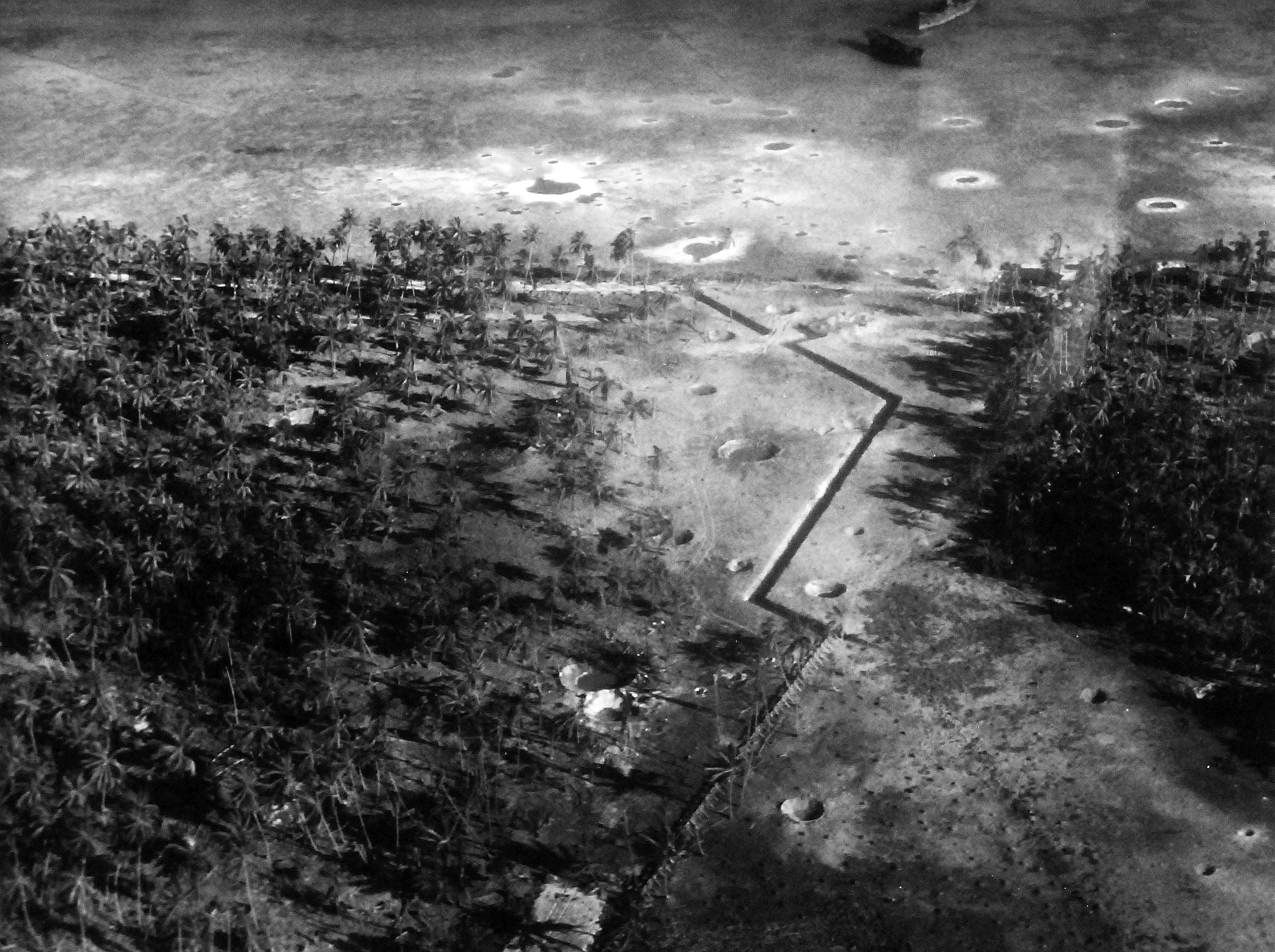
Aerial reconnaissance photograph of an antitank ditch and coconut log barrier at Butaritari Atoll, Gilbert Islands. Official U.S. Navy photo, accession no. 80-G-204730, Naval History and Heritage Command
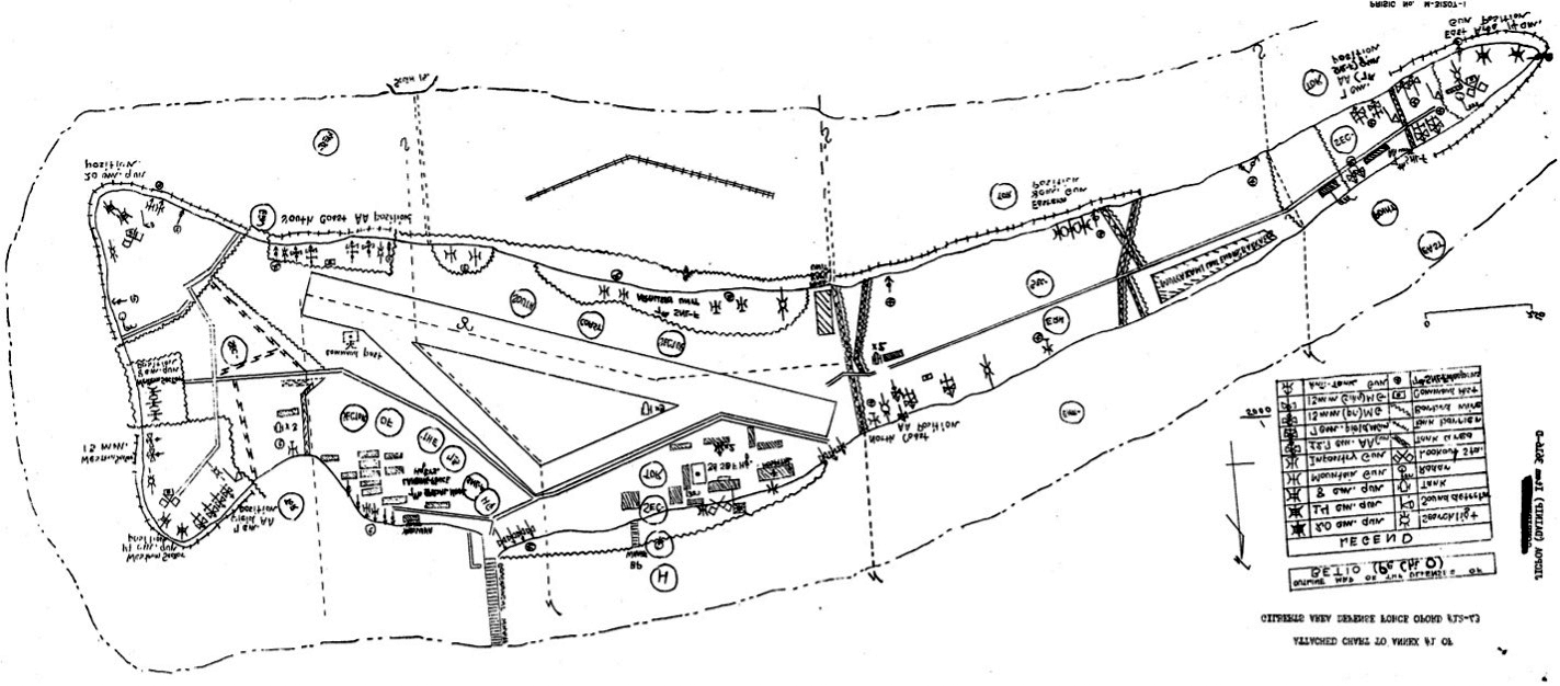
Translated defensive plan for Betio Island from RAdm Keiji Shibasaki’s orders. Pacific Ocean Areas Joint Intelligence Center, “Tarawa Organization Tables and Map as included in Gilbert Area Defence Opord #12-43,” 8 December 1943, Gilbert Islands Collection, COLL 3653, box 5 Gilberts: Tarawa, 1943–1944, folder 1, Archives Branch, MCHD, Quantico, VA, Annex no. 1
Rear Admiral Shibasaki established his defensive priorities based on the assumption that any U.S. assault would land on the southern or western beaches of Tarawa just as the Japanese had done.27 Accordingly, the four 8-inch naval guns forming the core coastal defense fires were oriented on these approaches while positions facing the lagoon to the north of Betio remained a lower priority for defensive works.28 Orders issued in October 1942 directed the Japanese forces to “knock out the landing boats with mountain gun fire, tank guns and infantry guns, then concentrate all fires on the enemy’s landing point and destroy him at the water’s edge.”29 In contrast to the extensive defenses at Tarawa, the Japanese preparations at Makin were limited, with positions concentrated around Butaritari village on the atoll’s largest island.30 Nevertheless, these positions were more than capable of contesting an amphibious landing. By weighting his positions against the anticipated U.S. avenues of approach, Shibasaki believed that he could defend the Gilbert Islands until a decisive naval counterattack could arrive.
Obstructing the Littorals
The Japanese defensive plan for the Gilbert Islands built on the significant natural barrier presented by fringing coral reefs. The V Amphibious Corps G-2 identified that on the ocean side reefs were normally “shallower, sharper, and narrower.”31 The lagoons presented lesser obstacles but were still “generally shallow, and are filled with sand bars, submerged reefs, rocks, and coral patches.”32 At Tarawa in particular, neap tides could prevent even small boats from crossing the reef crests.33 On the day of the assault, a neap tide left less than 2.5 feet of water above the reef at high tide.34 While coral reefs presented an imposing barrier to an amphibious assault, Shibasaki’s defensive force worked to enhance these obstacles further.
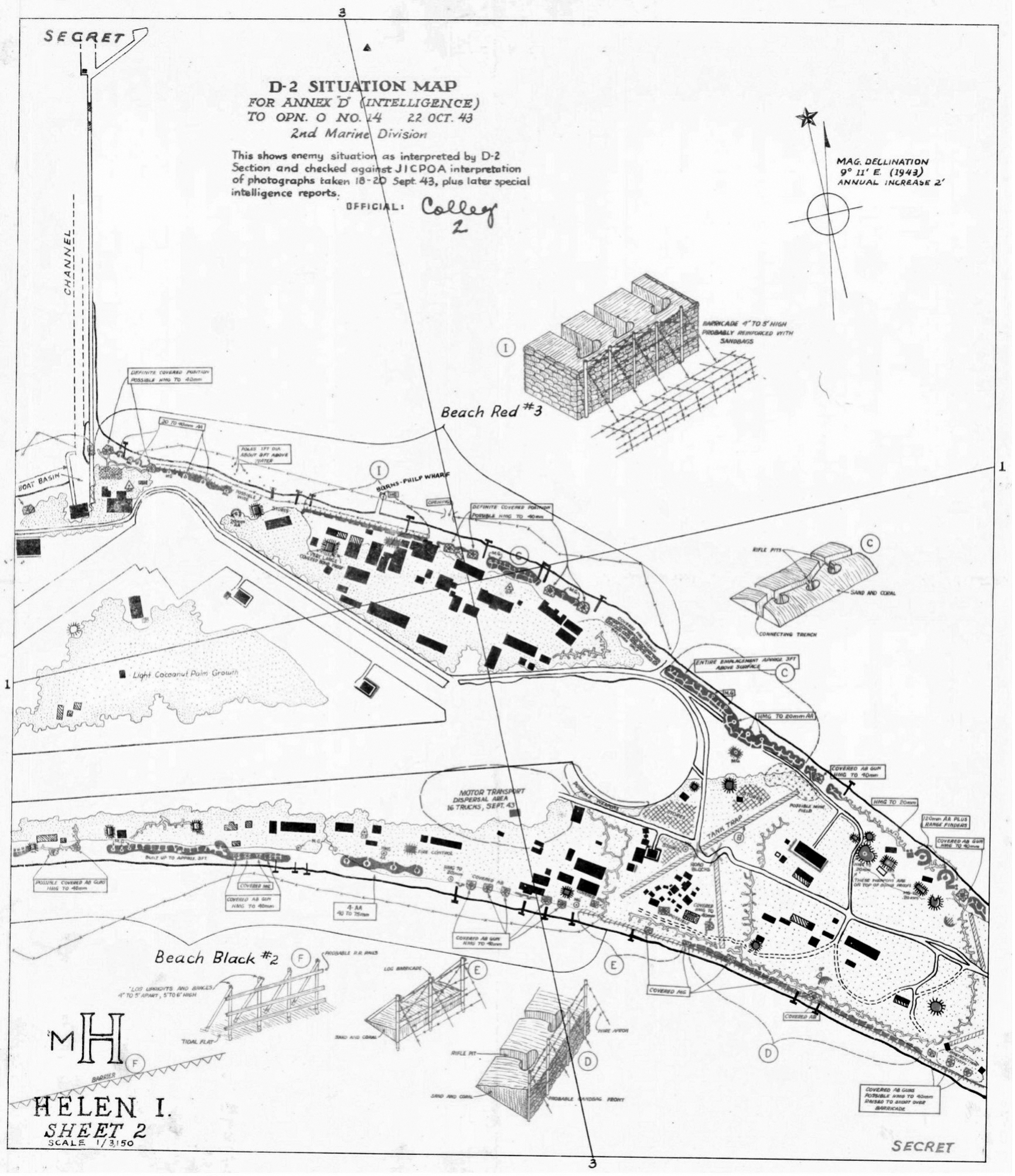
2d Marine Division D-2 map sheet 2 of 3 highlighting obstacles emplaced at Tarawa. 2d Marine Division D-2, “Helen Island Intelligence Map, 2 of 3,” Gilbert Islands Collection, COLL 3653, Archives Branch, MCHD, Quantico, VA
At Tarawa, Japanese forces emplaced extensive obstacles offshore, in shallow water, across the beaches, and inland. Shibasaki focused on “enhancing the southern, western, and northeastern beaches by priority, where he expected the Americans to land.”35 Antishipping mines were fixed to coral on the reefs while antipersonnel mines were emplaced on the beaches.36 In addition to mines, “AT ditches, beach barricades, log fences and concrete tetrahedrons on the fringing reef, double apron high-wire fence in the water near the beach, and double apron low-wire on the sand beach itself” were integrated with direct-fire weapons.37 Further, a four-foot tall coconut log seawall was established at the high watermark to impede inland vehicle movement.38 By canalizing assault watercraft as they approached the beaches, Shibasaki sought to maximize the effectiveness of his direct-fire weapons before any assault force could get to shore.39 The complexity and scale of Tarawa’s littoral obstacles gave Shibasaki justifiable confidence.
At Makin Island, resource shortfalls prevented Shibasaki from mirroring the extensive man-made obstacles emplaced at Tarawa. These shortfalls resulted in part from the successful disruption of Japanese merchant shipping by U.S. submarines.40 Natural obstacles were also more subdued at Butaritari, although fringing coral reefs were still present. Japanese forces defending Makin Island prioritized obstacles near their primary position at Butaritari village, establishing antitank ditches to the east and west “running generally in a zigzag path from lagoon to ocean shore.”41 These ditches were reinforced with coconut log barricades and long barbed-wire obstacles.42 Japanese forces missed the opportunity to emplace minefields at Makin; instead, the detachment made the most of locally available resources.43 While the obstacle development at Makin was significantly less progressed than at Tarawa, it was nevertheless sufficient to pose significant concerns for the U.S. Army’s 27th Infantry Division.
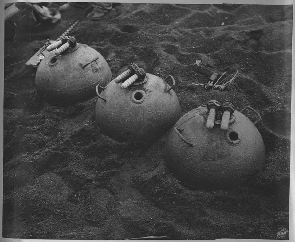
Japanese Type 96 mines consolidated for destruction at Tarawa. “Japanese Type JE Anti-Boat Mine,” Tarawa1943.com,
accessed 9 March 2024
At both Tarawa and Makin, nonexplosive obstacles formed the core of Shibasaki’s obstacle plan. Major Dempachi Kondo, a member of the Imperial General Headquarters staff, led the upgrade program in the Gilbert Islands while the 111th Construction Battalion, led by Lieutenant Isao Murakami, delivered the required works.44 Had the supplies Shibasaki was expecting arrived, he intended to establish at least “forty-five hundred obstacles.”45 At Betio, the Japanese emplaced an “abundance of horned scullies, steel-tipped tetrahedrons, and coral rock cairns dotting the offshore approaches” as well as “double-apron barbed wire and steel cable” obstructing the beaches.46 At the high water mark, Lieutenant Murakami established a four-foot tall seawall around almost all of Betio’s perimeter by driving coconut logs into the ground.47 Trees were sourced from the outer islands to avoid disrupting camouflage and concealment on the occupied islands.48 At Makin, nonexplosive obstacles included 500-foot-long log barricades, 15-foot-wide triangular barricades, as well as long barbed-wire obstacles.49 Two days prior to the U.S. D-Day, Japanese forces were still establishing new obstacles. Seventh Air Force imagery collected that day identified new horned scullies and tetrahedrons emplaced across half of the reef in front of Red Beach Three.50 While simple to construct, Japanese nonexplosive obstacles created effective engagement areas ready for the arrival of any U.S. assault.
To reinforce his main effort at Tarawa, Shibasaki emplaced almost 3,000 mines.51 Shibasaki had intended to reinforce the northern defenses with further mines, however, the additional resources necessary to complete these preparations had not yet arrived.52 Antishipping mines were employed on the reef “moored to coral heads beneath the surface,” as well as in shallow water.53 Model 96 mines were used for this purpose; these mines employed “two lead alloy horns. . . . pressure on either of these horns . . . activates the chemical electric fuze thus detonating the mine.”54 Each Model 96 mine contained nearly 21 kilograms of explosive, more than enough to destroy assault watercraft.55 On land, Model 99 armor-piercing mines were employed to target vehicles while Model 93 pressure mines were employed to target personnel.56 At Makin Island, “several hundred mines we found in a warehouse, but none had been laid.”57 Fortunately for the 2d Marine Division at Tawara and the 27th Infantry Division at Makin, the planned amphibious assaults landed where the majority of the Japanese mines were not emplaced.
Finding the Gaps
Prior to the selection of the Gilbert Islands as an objective, U.S. planners had minimal information about the disposition of the Japanese defenses and no information about the nature of the Japanese obstacles. Rear Admiral Turner reported that these shortfalls were overcome through the combination of “large numbers of vertical and oblique photographs” taken by aircraft, “horizontal panoramic photographs” taken by the submarine USS Nautilus (SS 168), and through discussions with former residents of the Gilbert Islands.58 Ultra intelligence intercepts also provided insights into Japanese troop movements and logistical requests, however, they could not provide a detailed understanding of natural and manmade obstacles.59 Ground reconnaissance prior to the assault was considered impracticable because of “the small land areas involved” and the “isolated position of the objectives.”60 Based on the gathered intelligence “it soon became apparent that, at least at TARAWA, landing boats could not pass through the protective wire and log barricades which had been erected seaward on the reefs and beaches” and that an alternative avenue of approach was required.61
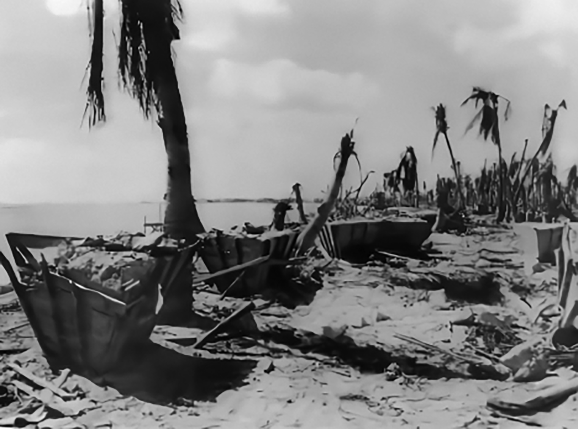
Japanese tetrahedron molds at Tarawa. 2d MarDiv Intelligence Section and POA Joint Intelligence Center, “Study of Japanese Defenses of Betio Island (Tarawa Atoll),” 171
For the V Amphibious Corps, the nature and location of Japanese defenses on the objective islands and the locations of suitable landing sites for “assault forces with landing boats, or amphibian tractors” were “essential elements of information.”62 Reports submitted by the Nautilus included “hazards to landings; condition of surf, reefs and beaches; characteristics of lagoon entrances; current data; sound conditions; activities on shore; general tidal data; photographs of radar [plan position indicator] PPI screen and photographs of shore line.”63 Nevertheless, the periscope photos captured in September and October 1943 “were too small a scale to show the details and were taken too low to show the location of obstacles with reference to the shoreline.”64 Submarine reconnaissance did, however, “report much of the missing data on hydrographic and beach conditions on both of the main islands.”65 While submarine reconnaissance made an important contribution to the selection of avenues of approach, in isolation it was insufficient to find the gaps in the Japanese obstacle plan.
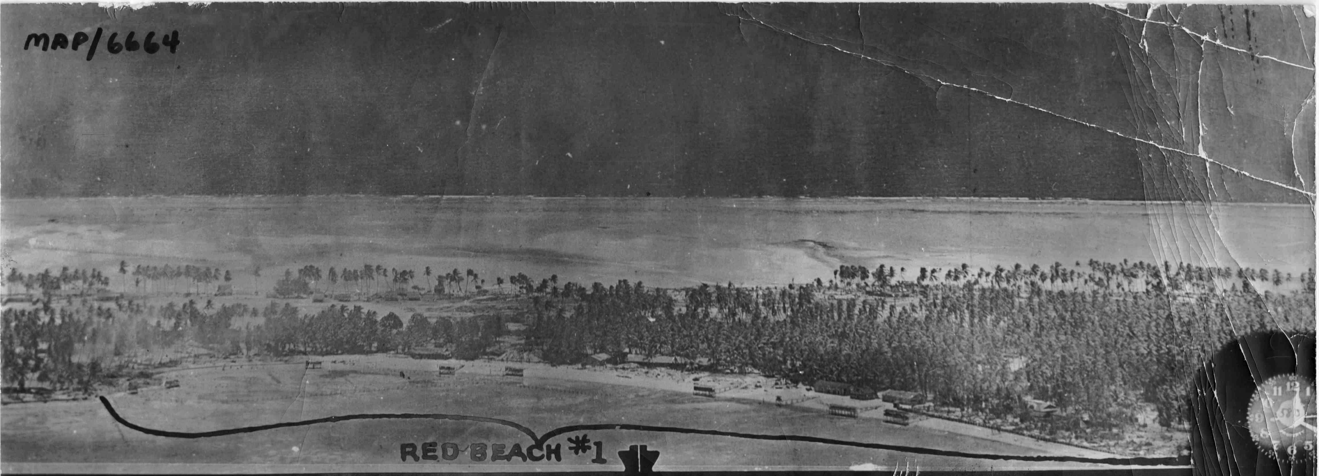
Aerial reconnaissance photograph of Betio Island, Tarawa Atoll. Consolidated B-24 Liberator Crew, “Map Image 6664,” 1943, Archives Branch, MCHD, Quantico, VA.
By supplementing intelligence staffs with former Gilbert Islands residents, the Fifth Amphibious Force gained further crucial information about the Operation Galvanic objectives. Personnel attached to planning teams “included Australian, New Zealand, and Fiji naval reserve officers, officials of the Western Pacific High Commission, Australian Army reserve officers and enlisted men, and civilians.”66 These former residents “provided information not readily available from other sources, on tides, local conditions, sailing directions, reef and beach conditions, surf, weather, and a wide variety of other subjects.”67 While they could not offer any information about the man-made obstacles that had been established since the Japanese occupation began, the hydrographic information they provided was critical to understanding the impact of natural obstacles. Like the information provided by the Nautilus, the information provided by former residents was insufficient on its own to find the gaps in the Japanese obstacle plan but made a key contribution to the overall picture.
While submarine reconnaissance and the insights from former Gilbert Islands residents were invaluable, the most effective source of intelligence during planning was aerial photographs taken by the Consolidated B-24 Liberators of the Seventh Air Force and Admiral John H. Hoover’s Task Force 57.68 Photoreconnaissance of Tarawa conducted during the periods 18–19 September and on 20 October 1943 delivered “excellent verticals and obliques” that proved “most helpful in studying beaches and locating weapons and installations.”69 Based on the available intelligence, the 2d Marine Division assessed that it was “extremely doubtful” that it could breach the obstacle barriers on the southern and western approaches to Betio.70 The eastern end of the island also appeared well-defended.71 In contrast, there were “some under-water wire entanglements on the north (lagoon) side of BETIO, but no indications of the heavier obstacles.”72 Aerial reconnaissance of Makin Island was less successful; however, it still allowed the 27th Infantry Division to identify the western end of Butaritari as the weak point.73 By successfully identifying the gaps in the Japanese obstacle plan, Joint ISR enabled the Fifth Amphibious Force to select avenues of approach where the residual obstacle effects could be mitigated.
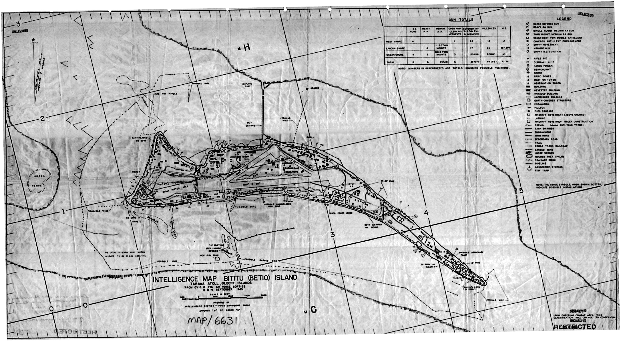
Intelligence map of Betio Island incorporating updated information gained through aerial reconnaissance flown on 18 and 19 September 1943. Fifth Amphibious Force, G2 Section, “Intelligence Map Bititu (Betio) Island,” September 1943, Gilbert Islands Collection, COLL 3653, map image 6631, Archives Branch, MCHD, Quantico, VA
Mitigating the Residual Risk
Knowing where the Gilbert Islands’ defenses were weakest did not make exploiting their vulnerabilities easy. First Lieutenant Wallace E. Nygren described the shaping effects of the offshore obstacles on his landing vehicle, tracked (LVT) 2 as he approached Red Beach Two: “Ahead of us in the water loomed a barrier of concrete tetrahedron blocks with iron rails projecting outward. . . . The gaps [between obstacles] were closed by rows of barbed wire strung on posts . . . the tractors had been forced together as we were funneled into the wire by the concrete blocks.”74 Nor were assessments of the expected obstacle without fault, despite warnings about the impact of neap tides contained in the Fifth Amphibious Force Operation Plan, 27th Infantry Division’s planners incorrectly assessed that tidal or hydrographic conditions would not restrict landings at Makin.75 Nevertheless, the Fifth Amphibious Force exploited the gaps in the Japanese defense, particularly at Tarawa where “the invaders entered the lagoon and attacked from the north, the one sector where Japanese defenses were yet incomplete, the place Shibasaki intended to sow last with antiboat mines.”76 By selecting the approaches that presented the least Japanese obstruction, the Fifth Amphibious Force enabled its combined arms teams to mitigate the residual risks.
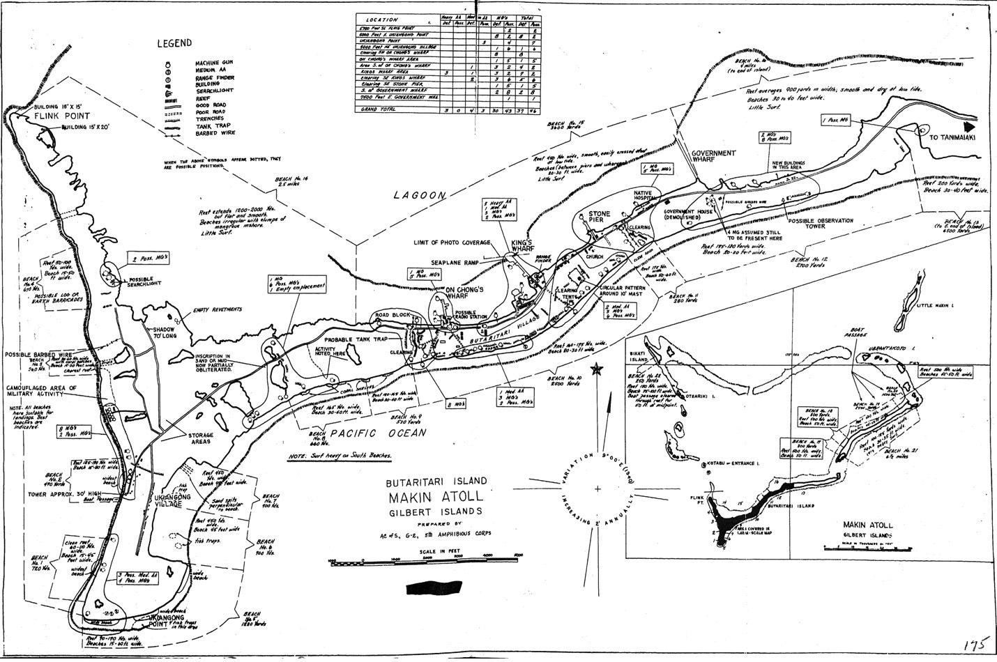
V Amphibious Corps G-2 map of Japanese defenses at Butaritari Atoll showing the detail revealed by Joint Force intelligence, surveillance, and reconnaissance efforts. V Amphibious Corps, “G-2 Study of the Theatre of Operations: Gilbert Islands, Nauru and Ocean,” 175
Despite choosing avenues of approach that avoided most Japanese obstacles, the assaulting forces still needed to mitigate Japanese direct and indirect fires. Extensive naval and air fires were employed to disrupt the Japanese positions prior to the assault. Four days of preparatory naval and air fires targeted Tarawa and Makin, while land- and carrier-based aircraft struck the Japanese airfields at Nauru, Jaluit, and Mili to deny Japanese air support to the defense.77 A further four hours of air and naval bombardment immediately preceded the landings to suppress and obscure Japanese coastal defense fires.78 The bombardment of Tarawa succeeded in degrading Japanese command and control: “Shibasaki had no idea whether his other forces in Makin, Nauru, and Ocean were also under attack.”79 As the battle progressed, Shibasaki and his staff were killed by naval fires, likely disrupting Japanese intentions to conduct a ground counterattack against the beachhead.80 While the fire support during Operation Galvanic failed to destroy the Japanese defenses, it nevertheless reduced the risks faced by the assaulting forces.
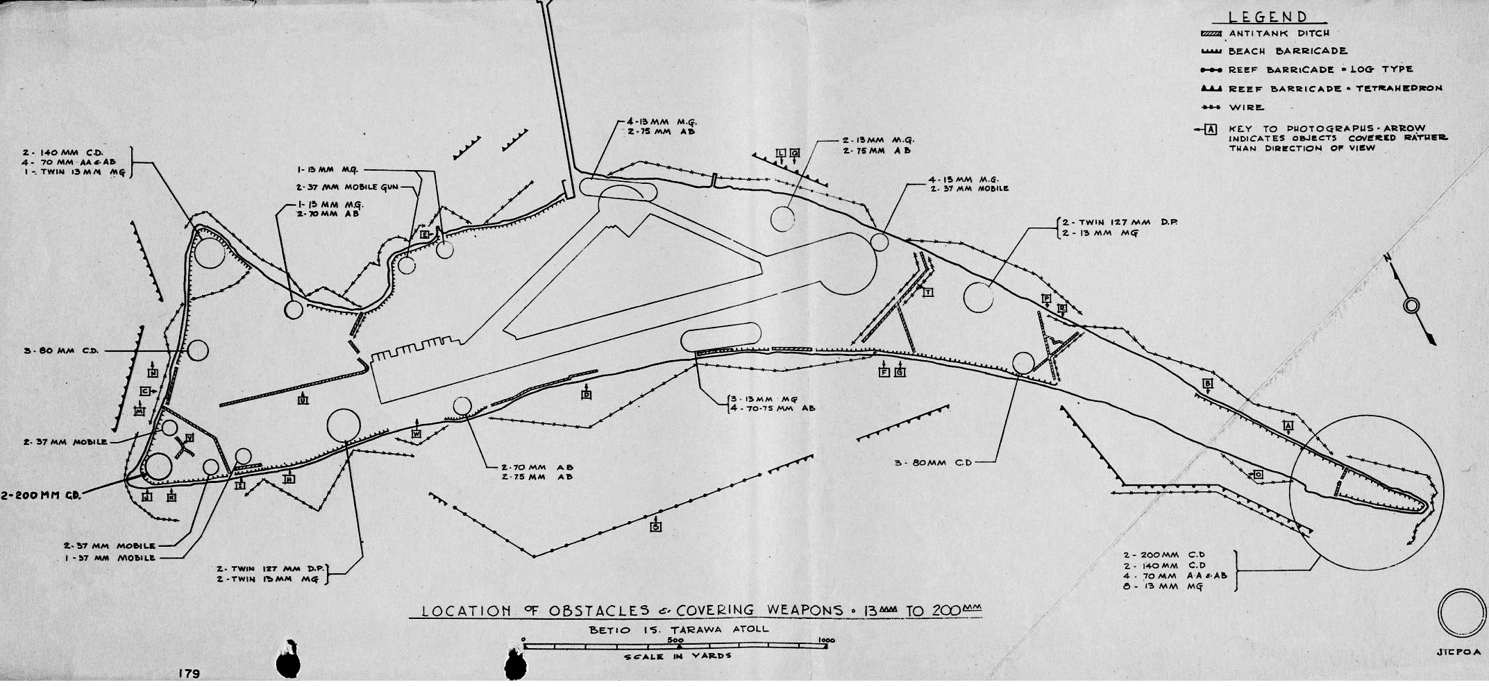
The confirmed locations of Japanese obstacles emplaced at Betio Island. The strong correlation between these locations and those assessed by the Fifth Amphibious Force G-2 in figure 9 demonstrates the effectiveness of intelligence, surveillance, and reconnaissance efforts during the planning for Operation Galvanic. 2d MarDiv Intelligence Section and POA Joint Intelligence Center, “Study of Japanese Defenses of Betio Island (Tarawa Atoll),” 179
Exploiting the gaps that Joint ISR had found would not have been possible without amphibious craft (the LVTs) that could cross the fringing reefs and bypass the primary Japanese engagement areas. The 2d Marine Division chief of staff wrote that “without LVTs, I doubt if we could ever have reached the beach” and that “every beach except the one we landed on was heavily mined, and also more heavily defended. I am absolutely sure that we could not have gotten ashore any place else initially.”81 The V Amphibious Corps report on the operation echoed this view: “Without the amphibian tractor, it is believed that the landing at TARAWA would have failed.”82 At Makin, the 27th Infantry Division had expected small boats to be capable of reaching the beaches, however, “they were held off shore by the very extensive reefs which surround this island.”83 Again, LVTs proved to be the key to maintaining momentum: “Troops were actually landed by transfer from the landing craft to the LVTs.”84 By providing cross-domain mobility, LVTs enabled the assaults at Tarawa and Makin to dislocate the Japanese obstacle plans.
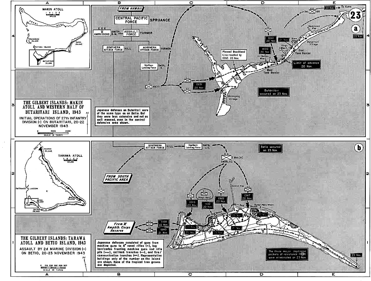
Schemes of maneuver at Makin (top) and Tarawa (bottom) Atolls during Operation Galvanic. “The Gilbert Islands, Initial Operations of the 27th Infantry and Assault by 2nd Marine Division, November 1943” atlases, U.S. Military Academy, West Point, Digital History Center
LVTs enabled the Fifth Amphibious Force to bypass the worst of the Japanese defenses; the residual obstacles nevertheless needed to be addressed. Following Landing Operations Doctrine, obstacles offshore were the responsibility of the naval “mine group” while the “demolition of enemy obstacles onshore” and “the removal of underwater obstructions at the beach” fell to engineers within the landing force.85 Despite fire from Japanese coastal defenses, the minesweepers USS Pursuit (AM 108) and USS Requisite (AM 109) marked the route into the Tarawa lagoon having “swept a channel three hundred yards wide and twenty feet deep.”86 In the shallower waters, LVTs employed “grapnels for destroying wire and thus opening boat routes.”87 As the assault reached the beaches, combat engineers from the 18th Regiment and the 102d Engineer Battalion moved with the initial assault wave to “clear a passage through any barbed wire or other underwater obstacles that might impede the succeeding landing craft” and to “clear beach . . . obstacles with Bangalore torpedoes.”88 With the shallow water obstacles reduced, only those on shore remained.
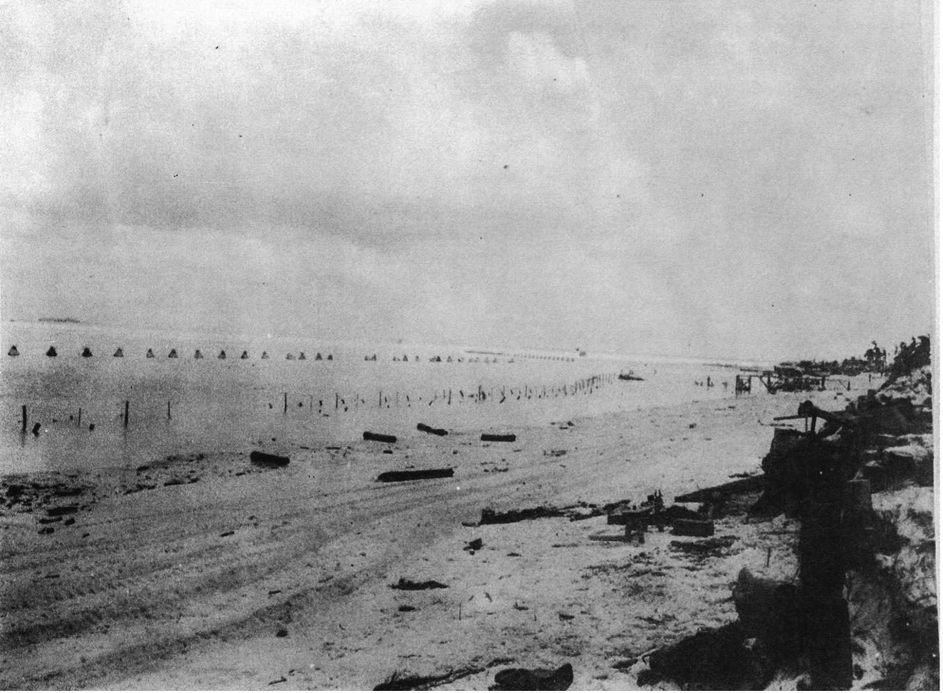
Japanese obstacles on the western beach at Betio including tetrahedrons, wire, and a coconut log sea wall. 2d MarDiv Intelligence Section and POA Joint Intelligence Center, “Study of Japanese Defenses of Betio Island (Tarawa Atoll),” 170
Combat engineers continued to provide support as the attacks progressed. While LVTs had enabled many of the obstacles at Betio and Butaritari to be bypassed, “very few of the LVTs could negotiate the vertical seawall” or readily cross the Japanese antitank ditches.89 Dismounted engineers conducted assault breaching using Bangalore torpedoes and satchel charges to support the Marine and Army infantry as they advanced.90 Bulldozers landed during the early stages of the assaults to further enable the reduction of Japanese obstacles and fortifications.91 Two combat engineers, First Lieutenant Alexander Bonnyman Jr. and Staff Sergeant William J. Bordelon, were awarded posthumous Medals of Honor for their actions.92 With the final obstacles overcome, the Fifth Amphibious Force declared Betio and Butaritari secure on 23 November 1943.
Conclusion
By exploiting Joint ISR capabilities, the Fifth Amphibious Force found the gaps in the Japanese defense of the Gilbert Islands. Intelligence gained from aircraft, submarines, signals interceptions, and human sources contributed to successfully identifying the northern approach to Tawara and the western side of Makin as the weak points in the Japanese obstacle plan. The Japanese plan was sophisticated, employing a wide range of different obstacles to channel and restrict assaulting forces offshore, in shallow water, on the beaches, and further inland. Nevertheless, the Fifth Amphibious Force overcame the defenses. Both the land and naval components suffered heavy casualties; however, the high cost of the operation reflects the scale of the challenge rather than a failure of planning, preparation, or execution.
While it may appear unlikely that a contemporary littoral force would choose to assault a defended beach, the compounding strategic considerations and compromises that led to the selection of the Gilbert Islands as an objective suggests otherwise. Mitigating littoral obstacles remains a significant challenge long after the conclusion of Operation Galvanic. While avoiding these areas is desirable, military forces may have no choice but to find a way through. Joint ISR enabled the Fifth Amphibious Force to find gaps, however other combined arms capabilities were also essential to exploiting the opportunities. Japanese obstacles could not have been bypassed without the cross-domain mobility provided by LVT-1 Alligators and LVT-2 Water Buffaloes. The residual risks presented by obstacles that remained in the path of the assaults could not have been mitigated without minesweepers and combat engineers. As the seizure of the Gilbert Islands demonstrates, the combination of these capabilities enables amphibious forces to overcome even complex obstacles.
Operation Galvanic by no means completely resolved the littoral obstacle problem. After the attack, Colonel Merritt A. Edson wrote to Headquarters Marine Corps that “some solution has got to be found to eliminate underwater mines, which I think is the most dangerous thing we have to combat at the moment.”93 Contemporary technologies further complicate the risks, enabling the rapid emplacement of obstacles on avenues of approach that strategic ISR has previously indicated are clear. Nevertheless, if beaches protected by complex obstacles must be seized, Operation Galvanic’s employment of Joint ISR, cross-domain mobility, and combined arms teams suggests a model for success.
•1775•
Endnotes
- Robert Sherrod, Tarawa: The Incredible Story of One of World War II’s Bloodiest Battles (New York: Skyhorse, 2013), 70.
- Col Joseph H. Alexander, Utmost Savagery: The Three Days of Tarawa (Annapolis, MD: Naval Institute Press, 1995), 37.
- Landing Operations Doctrine, Fleet Training Publication (FTP) 167 (Washington, DC: U.S. Government Printing Office, 1938), 5. This doctrine, which was employed during the planning for Operation Galvanic, stated that “it is a sound principle in the conduct of landing operations to avoid landing against strongly organized positions unless such action is the only means of carrying out the assigned task within the time available. In general, such organized positions can be located only by adequate and thorough reconnaissance.”
- Sherrod, Tarawa, 74.
- 2d Marine Division, “Operation Order No. 14 Gilbert Islands–Tarawa,” 25 October 1943, Gilbert Islands Collection, COLL 3653, box 2 Gilberts: Tarawa, 1943, folder 3, Archives Branch, Marine Corps History Division (MCHD), Quantico, VA, E2-5.
- Philip A. Crowl and Edmund G. Love, The War in the Pacific: Seizure of the Gilberts and Marshalls, United States Army in World War II (Washington, DC: Office of the Chief of Military History, Department of the Army, 1955), 26.
- Crowl and Love, Seizure of the Gilberts and Marshalls, 26.
- Craig L. Symonds, Nimitz at War: Command Leadership from Pearl Harbor to Tokyo Bay (New York: Oxford University Press, 2022), 187.
- Crowl and Love, Seizure of the Gilberts and Marshalls, 28.
- Symonds, Nimitz at War, 189.
- Alexander, Utmost Savagery, 27.
- Crowl and Love, Seizure of the Gilberts and Marshalls, 33.
- Crowl and Love, Seizure of the Gilberts and Marshalls, 41.
- Alexander, Utmost Savagery, 29.
- Alexander, Utmost Savagery, 29.
- Alexander, Utmost Savagery, 29.
- Alexander, Utmost Savagery, 28–29, 63. Throughout the planning and execution of Operation Galvanic, Adm Raymond A. Spruance remained concerned about the prospect of a Japanese naval counterattack, recognizing that “the Japanese fleet was about as strong as ours . . . it was free to operate against us on interior lines . . . [and] the Japanese air was still strong and aggressive.” In response, RAdm Turner positioned his flagship, the USS Pennsylvania (BB 38), on the most likely naval avenue of approach near Makin Island rather than remaining near Tarawa.
- Alexander, Utmost Savagery, 25.
- Alexander, Utmost Savagery, 26.
- Alexander, Utmost Savagery, 26.
- The Capture of MAKIN: 20 November–24 November 1943, American Forces in Action Series (Washington DC: Historical Division, War Department, 1946), 3; and Alexander, Utmost Savagery, 26–28.
- The Capture of MAKIN, 3.
- Alexander, Utmost Savagery, 42.
- Intelligence Center Pacific Ocean Areas, “Enemy Positions: The Marshall–Gilberts Area,” 1 June 1943, Gilbert Islands Collection, COLL 3653, box 2 Gilberts: Tarawa, 1943, folder 1–2, Archives Branch, MCHD, Quantico, VA, 212; and Alexander, Utmost Savagery, 35.
- Alexander, Utmost Savagery, 37.
- Alexander, Utmost Savagery, 58.
- Alexander, Utmost Savagery, 21.
- Alexander, Utmost Savagery, 37–40.
- Alexander, Utmost Savagery, 39.
- Crowl and Love, Seizure of the Gilberts and Marshalls, 53, 99.
- V Amphibious Corps, “G-2 Study of the Theatre of Operations: Gilbert Islands, Nauru and Ocean,” 20 September 1943, Gilbert Islands Collection, COLL 3653, box 2 Gilberts: Tarawa, 1943, folder 6–7, Archives Branch, MCHD, Quantico, VA, 2.
- V Amphibious Corps, “G-2 Study of the Theatre of Operations: Gilbert Islands, Nauru and Ocean,” 4.
- Neap tides occur when the tidal effects of the Sun and Moon cancel each other, resulting in high tides that are lower than average.
- Symonds, Nimitz at War, 210; and Alexander, Utmost Savagery, 88. The impact of the tide at Tarawa was “not entirely a surprise; the operational plan had cautioned that during a neap tide there might be only ‘one to two feet of water’ over the coral shelf.” No boats would successfully pass over the reef crest during the first 30 hours of the battle; only landing vehicles, tracked (LVTs) could support the assault during that time.
- Alexander, Utmost Savagery, 58.
- 2d Marine Division (2d MarDiv) Intelligence Section and Pacific Ocean Areas (POA) Joint Intelligence Center, “Study of Japanese Defenses of Betio Island (Tarawa Atoll),” 20 December 1943, Julian C. Smith Collection, COLL 202, 1892–1976, box 8, folder 10, Archives Branch, MCHD, Quantico, VA, 6; and Alexander, Utmost Savagery, 123.
- 2d MarDiv Intelligence Section and POA Joint Intelligence Center, “Study of Japanese Defenses of Betio Island (Tarawa Atoll),” 6; and Sherrod, Tarawa, 45, 67.
- Sherrod, Tarawa, 37, 60; Alexander, Utmost Savagery, 38, 60.
- 2d MarDiv Intelligence Section and POA Joint Intelligence Center, “Study of Japanese Defenses of Betio Island (Tarawa Atoll),” 6.
- Alexander, Utmost Savagery, 72.
- Crowl and Love, Seizure of the Gilberts and Marshalls, 53–67. Having assessed that “the first main obstacle to a quick capture of the island would be the West Tank Barrier,” the 27th Infantry Division staff developed a plan to quickly envelop the western antitank ditch and dislocate the Japanese defenses.
- V Amphibious Corps, “G-2 Study of the Theatre of Operations: Gilbert Islands, Nauru and Ocean,” 70.
- The Capture of MAKIN, 61.
- Alexander, Utmost Savagery, 36–37.
- Alexander, Utmost Savagery, 71.
- Alexander, Utmost Savagery, 60. Horned scullies were concrete blocks with metal spikes protruding from the top to pierce the hulls of landing craft. Tetrahedrons were concrete pyramids designed to block or expose the underside of landing craft or armored vehicles. Cairns were piles of rock or coral that used their mass to block landing craft and vehicles.
- Sherrod, Tarawa, 37; and Alexander, Utmost Savagery, 38.
- Alexander, Utmost Savagery, 40.
- V Amphibious Corps, “G-2 Study of the Theatre of Operations: Gilbert Islands, Nauru and Ocean,” 70.
- Alexander, Utmost Savagery, 59.
- Alexander, Utmost Savagery, 58.
- Alexander, Utmost Savagery, 21.
- 2d MarDiv Intelligence Section and POA Joint Intelligence Center, “Study of Japanese Defenses of Betio Island (Tarawa Atoll),” 6; and Alexander, Utmost Savagery, 123.
- Handbook on Japanese Military Forces, TM-E 30-480 (Washington, DC: U.S. Government Printing Office, 1944), 215–16; and “Japanese Type JE Anti-Boat Mine,” Tarawa1943.com, accessed 9 March 2024.
- Handbook on Japanese Military Forces, TM-E 30-480, 215–16.
- Intelligence Bulletin March 1944, vol. 2, no. 7 (Washinton, DC: War Department, 1944), 9; and Handbook on Japanese Military Forces, TM-E 30-480, 214–15.
- Handbook on Japanese Military Forces, TM-E 30-480, 138.
- Commander, Fifth Amphibious Force, “Report of Amphibious Operations for the Capture of the GILBERT ISLANDS,” 4 December 1943, Gilbert Islands Collection, COLL 3653, box 4 Gilberts: Tarawa: Operation Reports, 1943–1944, folder 1, Archives Branch, MCHD, Quantico, VA, 9.
- Alexander, Utmost Savagery, 59.
- Fifth Amphibious Force, “Report of Amphibious Operations for the Capture of the GILBERT ISLANDS,” C-2.
- Fifth Amphibious Force, “Report of Amphibious Operations for the Capture of the GILBERT ISLANDS,” 9–10.
- V Amphibious Corps, “Corps Operation Plan No. 1-43 Gilbert Islands,” 13 October 1943, Gilbert Islands Collection, COLL 3653, box 1 Gilberts: Tarawa: 5th Amphibious Corps Operation Plan, 1943, folder 1, Archives Branch, MCHD, Quantico, VA, H-1–H-2.
- Fifth Amphibious Force, “Report of Amphibious Operations for the Capture of the GILBERT ISLANDS,” C-2.
- V Amphibious Corps, “Report of Gilbert Islands Operation,” 11 January 1944, Gilbert Islands Collection, COLL 3653, box 3 Gilberts: 5th Amphibious Corps, Report on Operations, 1944, Archives Branch, MCHD, Quantico, VA, C-2.
- Crowl and Love, Seizure of the Gilberts and Marshalls, 48.
- Crowl and Love, Seizure of the Gilberts and Marshalls, 50.
- Fifth Amphibious Force, “Report of Amphibious Operations for the Capture of the GILBERT ISLANDS,” C-3–C-4.
- Alexander, Utmost Savagery, 59.
- V Amphibious Corps, “Report of Gilbert Islands Operation,” C-2.
- 2d Marine Division, “Estimate of the Situation–Gilberts,” 5 October 1943, Gilbert Islands Collection, COLL 3653, box 2 Gilberts: Tarawa, 1943, folder 5, Archives Branch, MCHD, Quantico, VA, 4, 22.
- 2d Marine Division, “Estimate of the Situation–Gilberts,” 22.
- 2d Marine Division, “Estimate of the Situation–Gilberts,” 4.
- V Amphibious Corps, “Report of Gilbert Islands Operation,” C-2.
- Alexander, Utmost Savagery, 87.
- Crowl and Love, Seizure of the Gilberts and Marshalls, 52.
- Alexander, Utmost Savagery, 21.
- Sherrod, Tarawa, 23.
- Sherrod, Tarawa, 23.
- Alexander, Utmost Savagery, 21.
- The 2d Marine Division chief of staff suggested that “a strong Jap counterattack that night would probably have been disastrous.” Merritt Edson, “Letter to Colonel G. C. Thomas,” 13 December 1943, Merritt Austin Edson Papers, MSS38133, box 5, Manuscript Division, Library of Congress, Washington, DC, 4; and Alexander, Utmost Savagery, 109.
- Edson, “Letter to Colonel G. C. Thomas,” 7.
- V Amphibious Corps, “Report of Gilbert Islands Operation,” 12; and Alexander, Utmost Savagery, 54. While many authors have highlighted an argument between RAdm Richmond Turner and MajGen Holland M. Smith about the necessity for additional LVTs, including Smith’s often-quoted ultimatum “no LVTs, no operation,” Turner held legitimate naval concerns about whether additional LVT-2s should be bought forward. Turner worried that the landing ship, tank, platforms needed to collect the LVT-2s would be exposed to Japanese submarine or air interdiction, further depleting scarce amphibious shipping. Nevertheless, the land-based risks were ultimately deemed higher, and the LVT-2s were provided.
- V Amphibious Corps, “Report of Gilbert Islands Operation,” B-7.
- V Amphibious Corps, “Report of Gilbert Islands Operation,” B-7.
- Landing Operations Doctrine, FTP 167, 33, 227.
- Alexander, Utmost Savagery, 77.
- Crowl and Love, Seizure of the Gilberts and Marshalls, 64.
- Crowl and Love, Seizure of the Gilberts and Marshalls, 66, 135.
- Alexander, Utmost Savagery, 87.
- Karl C. Dod, The Corps of Engineers: The War Against Japan, United States Army in World War II (Washington, DC: U.S. Army Center of Military History, 1987), 382–83; V Amphibious Corps, “Report of Gilbert Islands Operation,” F3-1; and Alexander, Utmost Savagery, 127.
- The Capture of MAKIN, 12; Sherrod, Tarawa, 36; and V Amphibious Corps, “Report of Gilbert Islands Operation,” F3-2. Thirty-eight bulldozers were landed at Makin Island alone.
- Alexander, Utmost Savagery, 50.
- Edson, “Letter to Colonel G. C. Thomas,” 8.
About the Author
Maj Matthew Scott is a currently serving Australian Army officer. He has commanded at troop and squadron level within 1 Field Squadron, 1st Combat Engineer Regiment, as well as serving within Headquarters 1st (Australian) Division, Headquarters Defence Force Recruiting, and the Royal Military College, Duntroon. Maj Scott is a graduate of the U.S. Marine Corps Command and Staff College and of the School of Advanced Warfighting.