Abstract: Africa’s Lake Chad is the convergence point of a complex humanitarian disaster courtesy of violence, climate change, and remote, ungoverned areas.1 As the hydrography of Lake Chad changes, decreasing in size by nearly 90 percent since the 1960s, the vanishing shoreline exposes new prospects for militarized actors to establish and retain control.2 This study asserts that Lake Chad’s changing hydrography has provided violent extremists with strategic opportunities to increase their foothold in the water-scarce Lake Chad Basin. Through an explanatory sequential mixed methods research design, this spatial analysis tests the relationship between conflict and environmental changes in the region. A linear regression model yields statistically significant quantitative evidence at a 95-percent significance level (? = 0.05) to support a strong and positive correlation between armed conflict and time (from 2009 to 2019) in this area. The spatial results indicate that armed conflict has increased across this specific landscape, which has been physically altered over time due to several socioenvironmental factors. These results expose serious security implications related to climate change, water scarcity, and increasing conflict. This article concludes by calling for an improved security strategy that addresses the conflict-climate trap seen across the Lake Chad Basin.
Keywords: Lake Chad, Africa, climate change, armed conflict, water scarcity, Boko Haram
In June 2019, approximately 300 Boko Haram insurgent fighters conducted a significant attack on an island military outpost off the shores of Lake Chad in Cameroon’s Far North Region.3 This was their first major attack on Cameroonian territory in several years, signaling a shift away from an operational strategy aimed at high-profile government targets in Nigeria’s Borno State.4 This strategy ostensibly marked a newer approach designed to exploit emerging landscapes and retain larger geographical areas as staging grounds for future operations. Lake Chad is the intersection of a complex humanitarian disaster courtesy of violent extremist organizations (VEOs), climate change, and remote, ungoverned areas.5 As Lake Chad’s hydrography—the physical features of water and adjacent land areas—changes, its vanishing shoreline exposes new prospects for militarized actors to establish and retain control.6
This article asserts that Lake Chad’s changing hydrography has provided violent extremists with strategic opportunities to increase their foothold in the water-scarce Lake Chad Basin. It follows Uche T. Okpara et al.’s proposed research framework, which calls for future studies to conduct syntheses examining the link between environmental change, vulnerability, and security issues.7 In doing so, this article aims to identify generalizable trends that will contribute to the growing evidence linking climatic fluctuations to conflict and instability.8 Given the substantial reductions in water levels described later in this article, readers should consider the Lake Chad Basin as an ideal model for examining the greater connection between climate change, water scarcity, and conflict. Climate change often appears to be a threat multiplier, overlapping with other problems to create security issues, especially in fragile countries with weak governance and failing security institutions such as those surrounding Lake Chad.9 The purpose of this spatial mixed methods study, then, is to examine the relationship between the changing physical environment of Lake Chad and the intensity of violent extremist activities in the surrounding area during the past decade.
This article will first be grounded within two well-established bodies of literature that cover the relationships between climate change, water and resource scarcity, and conflict. Next, a conceptual framework will be used to trace both the evolution of Lake Chad’s hydrography and the emergence of violent extremism in its vicinity. By establishing methodological congruence, the conceptual framework will then lead into the case study.10 Here, a mixed methods study (i.e., quantitative testing and spatial analysis) will generate results that tie directly to a subsequent implications section. Finally, this article will conclude by calling for an improved security strategy that addresses the conflict-climate trap seen across the Lake Chad Basin.
Climate Change and Conflict: Causation or Multiplication?
At its highest level, this article will fit within the robust literature linking climate change to conflict.11 This well-documented connection continues to grow, although the degree to which the relationship is causational or correlational remains contested today.12 One of the key early contributors to the field, Canadian political scientist Thomas F. Homer-Dixon, believed that environmental changes could lead to various types of acute conflict.13 His theoretical foundation paved the way for research hypotheses exploring complex and nuanced environmental-social systems. Building on this foundation, Wenche Iren Hauge and Tanja Ellingsen later concluded that environmental degradation leads to more conflict-prone settings.14 Despite their early development of causal pathways in the climate-conflict relationship, they were careful to acknowledge other economic and political factors that may be stronger predictors of conflict than environmental change. The presence of these confounding variables within the climate-conflict nexus is a major reason why many scholars and policymakers have been unable to reach a consensus about causal factors driving conflict.15
A more recent debate within the climate-conflict nexus surrounds the idea of climate change as a threat multiplier. Initially coined by the CNA’s Military Advisory Board, the threat multiplier concept views climate change as an exacerbating element within regions of the world that are already volatile and sociopolitically unstable.16 Here, conditions associated with climate change, such as rising sea levels and increasing average global temperatures, burden struggling economies, strain social tensions, and aggravate political instabilities.17 In each case, these underlying pressures were preexisting and climate change acted as a catalyst. A decade after the threat multiplier’s introduction in academic literature, Jan Selby et al. questioned its validity in an empirical setting.18 The Syrian Civil War (2011–present) was used as a case study to argue that there was no evidence that climate change directly caused the conflict’s origins. Like Emily Gilbert’s work, Selby et al. problematized the securitization of climate change, pleading for researchers to demonstrate better caution when aiming to demonstrate climate’s causal effect on conflict.19
While the other side of this debate also calls for caution in the research process, it recognizes the critical distinction between causality and contribution as well as the dangers associated with conflating the two, as Selby et al. appears to have done.20 For example, Cullen S. Hendrix acknowledges the tremendous difficulty in assigning climate-based causation to conflict and instead recommends that scholars, “investigate how climate shocks and climate change interact with existing political, social, demographic and economic contexts to result in violence—or not.”21 This is the core of the threat multiplier concept: not to prove that climate change caused a particular conflict but rather to show how its multiplier effects worsened fragile situations and amplified societal risk.22 This requires researchers to disentangle key individual variables across the climate-conflict nexus, which can differ by conflict type and/or regional context.23 The case study presented later in this article follows the threat multiplier camp, as climate change continues to intensify the prevailing instabilities across the Lake Chad Basin.
It is important to frame this article within a context of climate change because of the well-documented literature suggesting that the changing environment brings about many security implications. These can range from collective security in the form of major geopolitical shifts to individual human security comprised of unprecedented challenges to vulnerable populations.24 The security implications of climate change stretch across the globe, from economic and food security issues in Mali, to a possible militarization in the Arctic, to the overwhelmingly vulnerable populations in disaster-susceptible geographies in South Asia.25 These implications will force a variety of stakeholders to adapt their security mechanisms, from the United Nations Security Council to the U.S. Department of Defense.26 One dominant threat, as Patrick Huntjens and Katharina Nachbar conclude in their review of threat multipliers, is the intensification of resource scarcities, which will likely trigger increased conflicts.27 From this perspective, one can shift attention to one of the ever-diminishing resources on the African continent: water.
Water Scarcity and Civil Instability
This article will also contribute to a growing body of literature on the relationship between water scarcity and conflict. Several scholars have argued strongly that water scarcity makes states more likely to experience conflict, whether it is intrastate civil instability or interstate riparian disputes.28 The same has held true for resource scarcities and their greater likelihoods of conflict.29 According to Gabriel Eckstein, water scarcity, when combined with the adverse effects of climate change, will continue to pose a serious threat to nations’ security.30 Although Giorgos Kallis and Christos Zografos warn researchers about applying simplified narratives to the climate-water-security nexus, since they can overlook crucial nuances applicable to context-specific situations, it is essential to continue critically examining these intricacies.31 For example, Alexander Carius, Geoffrey D. Dabelko, and Aaron T. Wolf argue that water could offer productive opportunities for cooperation and conflict prevention. However, from the critical lens applied to the case study in this article, it is important to recognize that violent extremists, such as those encroaching on Lake Chad, may also be seeking to destabilize such conditions.32
The case study below follows a call from Marcus DuBois King, who recognizes a need for more specific research on the climate-conflict connection, such as fewer variables in tighter geographical spaces.33 This case study contends that violent actors can manipulate water sources to weaponize them, giving themselves certain strategic advantages over their opponents. This is not a new concept, as conflicts dating back to the Greek and Roman periods saw opposing sides wield water in their favor.34 In recent decades, the literature points to scores of examples where terrorist organizations have either targeted water infrastructure or populations within transboundary water basins.35 The latter case is especially relevant to Boko Haram in the greater Lake Chad Basin, with their predatory behavior toward food- and water-insecure populations.36 As international humanitarian law is slow to address the weaponization of water, violence against water systems remains likely to attract VEOs.37
The Syrian Civil War is perhaps one of the clearest examples of how violent extremists can employ a deliberate water strategy to strengthen their transboundary positions. In this case, water conflicts had been brewing in the region for decades, as broad religious, economic, and sociopolitical factors shaped development disputes over naturally scarce water resources.38 The Middle East saw tremendous periods of drought between 2007 and 2010, compromising several countries’ adaptive capacities and establishing the foundation for subsequent conflict.39 As Syria moved into a full-fledged civil war, the Islamic State of Iraq and the Levant (a.k.a. Islamic State of Iraq and Syria, or ISIS) captured dams across the Euphrates-Tigris Basin, contaminated water resources, and restricted access to water supplies.40 They even used this access, or rather lack thereof, to drive recruiting efforts, coercing desperate populations into obedience through water rights.41 Water became their way of gaining political legitimacy while simultaneously enabling their means of agricultural production.42 While the underlying sociopolitical contexts will surely change, it is important to apply lessons learned from the well-documented Syrian conflict to other contexts where water might be a key factor.
Figure 1. The conceptual framework for this study, which traces the two themes at the center of this research: the hydrographic change of Lake Chad since 1973 and the emergence of violent extremism in the same region beginning around 2009
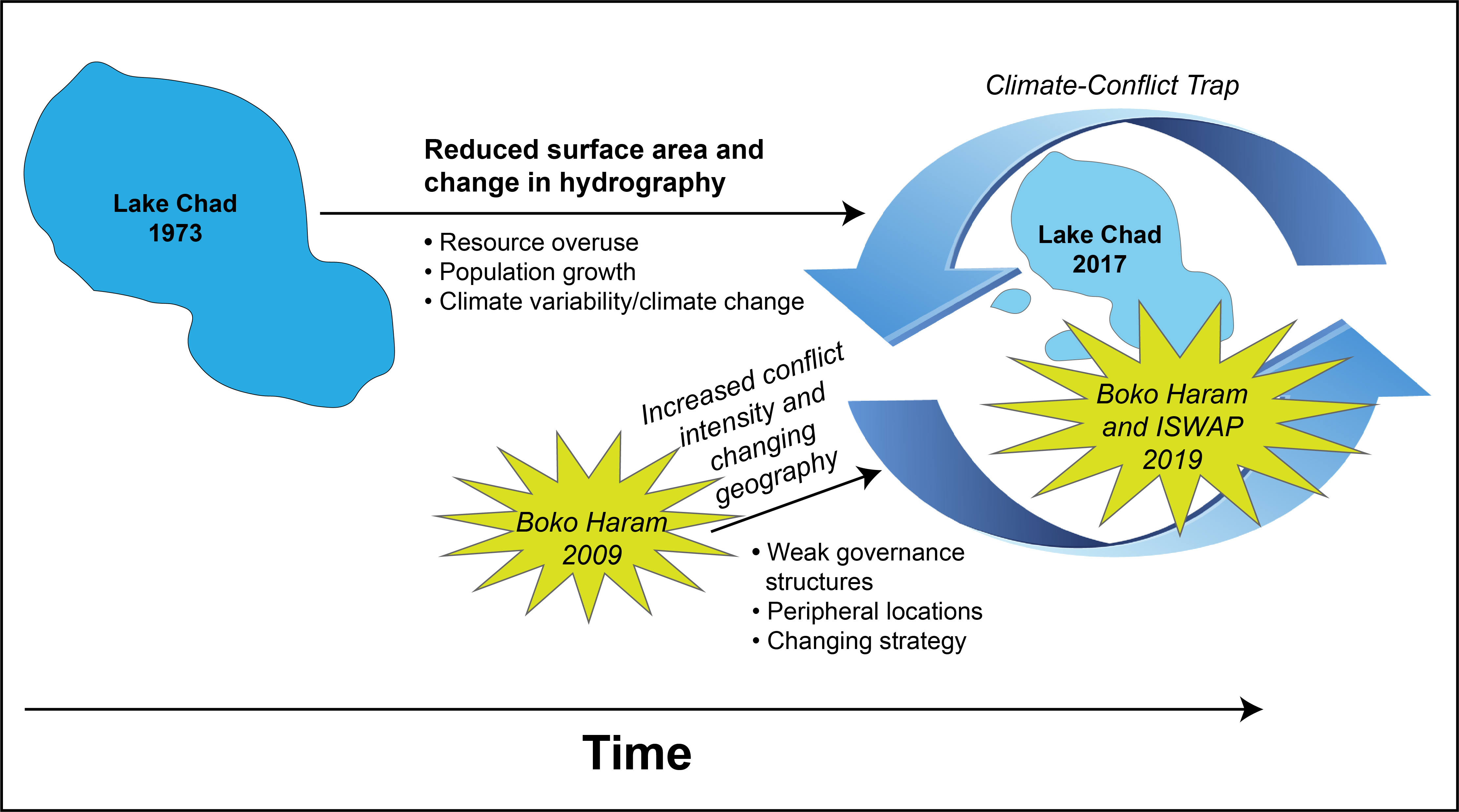
Source: courtesy of the author, adapted by MCUP.
Lake Chad’s Changing Hydrography
The conceptual framework illustrated in figure 1 serves as a pragmatic guide for tracing the relationship of interest to this study, which is the intersection between Lake Chad’s reduced shoreline and an increase in violent activity witnessed since Boko Haram’s rise to prominence in 2009.43 Lake Chad is one of the largest freshwater providers in Africa, a continent often characterized by its dramatic landscapes, large populations, and competition for scarce natural resources. It is also a unique transboundary natural reserve that connects people across borders and livelihoods.44 Not only does the lake itself touch Chad, Cameroon, Niger, and Nigeria, but its basin also extends to Algeria, the Central African Republic, and Sudan.45 Within this region, it provides freshwater for irrigation and personal consumption for a staggering 30 million people.46 This population spans the basin’s unique ecosystem, which consists of a number of wet zones, deserts, open-water areas, and fluctuating shorelines.47 Given the scale of population and landscape, it is no wonder why any changes to the physical attributes of the lake may correspond with dramatic social ramifications.
Lake Chad’s hydrography is quite difficult to assess over time.48 There is mounting evidence, however, that suggests a long-term shrinking of open water and evolution into other geographic features such as islands or marshlands. Hydrological modeling and satellite imagery have revealed several alarming components of Lake Chad’s changing hydrography during the last five decades. Perhaps one of the most oft-cited recent statistics is that the lake has witnessed a 90 percent reduction in its surface area since the 1960s.49 The two satellite images of Lake Chad that appear here, one from the Landsat 1 satellite in 1973 and the other from Landsat 8 in 2017, offer a glimpse of the changing hydrography over time. These images combine visible and infrared lights to differentiate between vegetation in red and water in blue/gray (figures 2 and 3).50
Figure 2. Landsat 1 satellite image of Lake Chad, 1973

Source: National Aeronautics and Space Administration (NASA).
Figure 3. Landsat 8 satellite image of Lake Chad, 2017
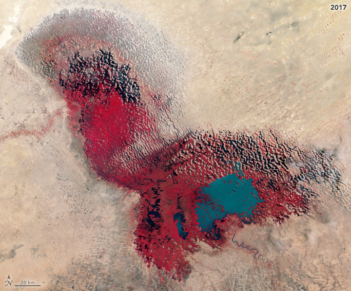
Source: National Aeronautics and Space Administration (NASA).
A perfect storm of environmental and social pressures shapes the lake’s physical landscape. No single culprit is at fault for the grim situation around the basin. The combination of these factors clearly describes a region stressed in resources and in a seemingly constant state of socioenvironmental change. On the environmental side, Janani Vivekananda et al. emphasize other factors beyond diminishing water levels, such as rising temperatures in the region and an increased uncertainty in the timing and quantity of rainfall.51 Similarly, there have been dramatic interseasonal and interannual changes among the basin’s three major spatial classes of open water, vegetation and marshlands, and bare soils.52 H. Gao et al. add to that list a unique geographical feature allowing the lake to split into the two smaller pools, which makes it more vulnerable to water loss.53 These two distinctly different seasonal lake pools each witness their own accessibility issues, variability, and predictability.54
Some argue that social pressures ranging from homogenous livelihood structures to low infrastructure and asset profiles are the key factors leading to the overexploitation of Lake Chad’s diminishing characteristics.55 Nowhere is this human-environment relationship clearer than in Michael T. Coe and Jonathan A. Foley’s research, which suggests that while climate variability dictates the interannual fluctuations of Lake Chad, human water use still accounts for almost 50 percent of the large decrease in hydrographic area.56 Freedom C. Onuoha cites three forces that are leading to Lake Chad’s demise: resource overuse, population explosion, and the climate variability associated with climate change.57 As a result, even the lake’s peripheral edges, which were once capable of supporting herders’ grazing livelihoods, no longer offer the sanctuary of pastoral landscapes.58 Although these findings provide essential insights for disaster risk reduction, they are not sufficient for understanding how the socioenvironmental relationship(s) of the Lake Chad Basin, exacerbated by the forces of climate change, might directly enable strategies of violence.
Violent Extremism on the Rise
Since the first decade of the twenty-first century, the Lake Chad Basin has offered perfect conditions for the violent extremist organization Boko Haram to emerge. Boko Haram operates in a remote, quadruple-border area of Nigeria, Niger, Chad, and Cameroon, far from national capitals and government attention. These border regions, such as Borno State in Nigeria and the Far North Region of Cameroon, have high inequality and low rule of law, are plagued with corruption, and offer little existential threat to their host countries’ powerful regimes.59 The peripheral region in northeastern Nigeria has long seen periods of marginalization and lawlessness since times of colonialization, as the British Empire found it cheaper to allow for a regional implementation of Islamic law than to impose their own civil laws. As a result, inherent tensions between Nigeria’s capital, Abuja, and its peripheral peoples in Borno State became normalized over time and created the conditions for radicalized groups to supersede the capacity of formal state institutions. Boko Haram formally originated in 2002, when Mohammed Yusuf, a follower of Salafi Islam, created the group with several college students branded as the “Nigerian Taliban.”60
What began as a relatively juvenile and aspirational organization has evolved into a full-fledged terrorist organization, largely due to two key events during the last decade. First, Boko Haram found its rallying cry after a Nigerian military offensive against the group in 2009 saw Yusuf captured and hundreds of Boko fighters killed in very public and extrajudicial executions.61 Second, Boko Haram finally caught the Western consciousness in 2014 after kidnapping 250 girls from a school in the Chibok village, deep in Borno State’s rural territory. At the same time, the insurgent forces shifted their strategy from primarily urban attacks on government buildings in Maiduguri to ruthless attacks, rape, and torture of civilians in the rural villages of Borno State.62 This prompted the start of today’s complex crisis around Lake Chad, specifically, because Boko Haram could finally hold large swaths of land, killing or displacing any resistors along the way.63
It is this clever shift to exploiting the territorial advantages of the Lake Chad landscape that makes Boko Haram’s strategy so alarming, especially from a military perspective. This is a page out of the insurgency textbook, as the insurgent’s irregular approach to conflict often allows them to “exploit the terrain and population as cover and concealment for their operations.”64 In fact, terrain analysis is one of the first steps in the U.S. military’s intelligence preparation of the battlefield (IPB) procedure, a critical process used to aid military commanders in their mission planning.65 Here lies the crux of this study. It is clear how strategically important Lake Chad is to the seven countries within its water basin. It is unclear, however, exactly how the changing terrain influences the strategic decisions of Boko Haram and the degree to which neighboring populations have become vulnerable to increased violence.
This is not the first study to examine environmental and conflict dynamics specific to the Lake Chad Basin. Okpara et al. argue that conflict is a probable outcome in areas where populations already face a host of context-specific social factors consistent with those presented in the preceding sections.66 Similarly, the risks stemming from the interaction between these conditions are what Chitra Nagarajan et al. refer to as a climate-fragility profile.67 The Lake Chad climate-fragility profile consists of three key risks: the conflict-induced undermining of community resilience, a resurgence in natural resource conflicts, and livelihood insecurity resulting in recruitment into armed groups. There is also a self-enforcing feedback loop called a climate conflict trap, in which climate change contributes to the drivers of conflict while conflict itself limits adaptation capacities to changing climate conditions.68 Returning to the threat multiplier concept, these underlying security threats and fragility traps are critical to note if one begins to examine how violence can easily accelerate in a region already under such duress.
The Lake Chad Basin as a Climate-Conflict Case Study
This study follows Ragnhild Nordås and Nils Petter Gleditsch’s call to explore the climate-conflict link by combining data sources from each category.69 The medium for this study is the ArcGIS geographic information systems software platform, which supported the spatial analyses of satellite imagery and latitude/longitude point data. Clionadh Raleigh and Henrik Urdal write that geospatial data “can sharpen our understanding of how local processes and national characteristics shape the context of conflict.”70 Similarly, Raleigh, Frank D. W. Witmer, and John O’Loughlin cite terrain, land cover, and the distribution of populations as just a few relevant variables to this study that influence the overall geography of war.71 In reviewing the political geography of climate change and conflict, Elizabeth L. Chalecki calls for research to move beyond theory and statistical correlation to test the climate-conflict link on a subnational scale.72 The study presented here will focus on the subnational regions surrounding Lake Chad that also consist of island properties, including the Far North Region of Cameroon, Borno State in Nigeria, the Lac region of Chad, and Diffa region in Niger. Spanning these regions, the study area for both analyses was an approximately 100-mile radius around Lake Chad, which is the estimated range of territory that Boko Haram and ISIS-West Africa holds from Lake Chad extending into northeastern Nigeria.73
This study includes input from an Armed Conflict Location and Event Data (ACLED) Project dataset. ACLED is a nonprofit organization that collects reported information on internal conflict, such as violent activity within states, which is coded for the type of conflict, actor, and location.74 ACLED researchers update the dataset weekly by assessing thousands of sources across traditional media articles, reports from international institutions and nongovernmental organizations, local data enumerators across several countries, and “new media” such as verified social media platforms. ACLED is ideal for this study because it was designed for both exploratory assessments of time-varying instances of violence and came formatted for dynamic conflict mapping technologies such as GIS.75 As of 2020, the ACLED database has been cited more than 900 times in credible, peer-reviewed academic journals on conflict resolution, political geography, and peace studies.
Recognizing an ostensible link between conflict and climate change, this case study employs a modification of John W. Creswell and Vicki L. Plano Clark’s explanatory sequential mixed methods research design. This design was used to examine quantitative data first before shifting to an explanatory spatial analysis to obtain greater insight into the climate-conflict relationship than addressing it in separate studies.76 It was important to first understand if the intensity of violent activity around Lake Chad actually represented any sort of significant trend. Thus, a linear regression model was used to determine if the dependent variable of conflict, measured by the annual number of ACLED incidents within the 100-mile radius around Lake Chad, correlated with the independent variable of time, measured by calendar years, during the 10-year period of Boko Haram’s rise from 2009 to 2019. In this type of analysis, one determines if there is an appropriate threshold to reject the null hypothesis, in which there is no relationship between the independent (or predictor) variable and the dependent (or outcome) variable. If the results exceed this threshold, the alternative research hypothesis can be accepted, showing that there is a relationship, or correlation, between the two variables.77 Table 1 shows the input data for this model, and table 2 displays the regression output using the Microsoft Excel Data Analysis plug-in.
Table 1. Number of ACLED conflict data points by year, 2009–19
|
Year
|
Number of ACLED incidents
|
|
2009
|
13
|
|
2010
|
52
|
|
2011
|
9
|
|
2012
|
102
|
|
2013
|
179
|
|
2014
|
251
|
|
2015
|
381
|
|
2016
|
363
|
|
2017
|
351
|
|
2018
|
410
|
|
2019
|
513
|
This table shows the number of ACLED incidents between 2009 and 2019 within a 100-mile radius around the 2019 boundaries of Lake Chad’s open water. Source: courtesy of the author, adapted by MCUP.
Table 2. Regression analysis summary for time as the predictor of conflict around Lake Chad
|
Variable
|
B
|
SE B
|
β
|
|
Intercept (Conflict)
|
-103,793.71
|
9,132.39
|
0.00
|
|
Year
|
51.65
|
4.53
|
0.00
|
Note: R2 = 0.94 (N = 11, p < .001). This table presents the linear regression output for table 1, where the dependent variable (the number of ACLED incidents) is regressed against the independent variable of time (measured by calendar year). Source: courtesy of the author, adapted by MCUP.
As table 2 illustrates, there was statistically significant evidence, at a 95 percent significance level (? = 0.05), to support a strong and positive correlation between conflict and time in this study. The p-value was less than 0.05, which means that the null hypothesis can be rejected and the result is most likely not due to chance or coincidence.78 The slope of the regression line is 51.65 which means that an increase in one calendar year results in about 51 conflict events. The regression equation here is y = (-103,794) + 51.65x. This can be used to predict future conflicts. For example, substituting the value 2,030 for x will yield 1,055 conflict events within the 100-mile radius around Lake Chad in the year 2030 alone if all external conditions or variables remain the same as today. The multiple R value, or the correlation coefficient, was 0.97, which represents a very strong and positive correlation because coefficient values fall between -1 and 1.79 Finally, the R-squared value of 0.94 shows that 94 percent of the variance in conflict can be explained by time. The bottom line here is that there are very compelling statistical indicators to show that the trend in conflict will only stand to worsen with time if the current state of affairs remains unchecked in the Lake Chad Basin.
Figure 4. ACLED conflict points since 2009 superimposed atop the 2017 Landsat 8 satellite image of Lake Chad
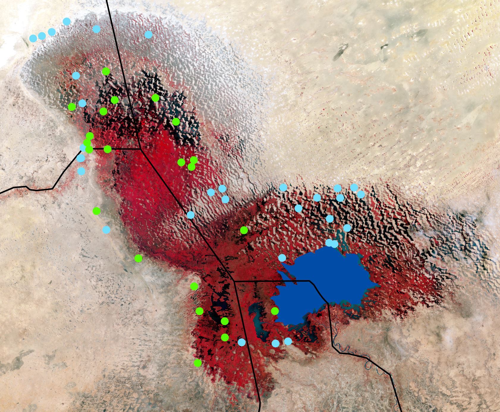
As this image illustrates, all conflict points would have been located within the 1973 shorelines of Lake Chad. Points in green would have been located on open water had they occurred in 1973. Source: National Aeronautics and Space Administration (NASA).
The defining feature of this study was the convergence of ACLED conflict data and NASA satellite imagery. Sheila L. Steinberg and Steven J. Steinberg emphasize the value of GIS for its ability to integrate many different types of data, which was made clear through a small series of technical steps here.80 Two key findings about armed conflict in the Lake Chad Basin emerged from this explanatory sequential research design. First, there was evidence that instances of armed conflict have occurred in places that were once submerged by the open water of Lake Chad. In fact, 152 total conflict events since 2009 were found within an area that was once located on or within the lake’s boundaries in 1973, as can be seen in figure 4. Of those events, 22 of them, or 14.5 percent, would have been located on open water in 1973. In other words, those 22 events would not have taken place in their precise locations had the water levels been the same today as they were less than 50 years ago. These 22 events resulted in 258 fatalities, 12.9 percent of the 1,999 fatalities arising across the 152 conflict events. Although 22 events is not an astronomical number, one could feasibly argue that all 152 conflict events are so physically close to what used to be open water that they also may not have occurred in 1973.
Second, it became clear that conflict in and around Lake Chad is increasing rapidly. Expanding the frame of reference, a 100-mile radius around the modern-day limits of open water in Lake Chad was identified to examine slightly more distant instances of conflict. This resulted in a staggering 3,108 data points since 1997, the year ACLED’s conflict database begins. Figure 5 reflects an exponential increase of conflict activity since Boko Haram rose to prominence in 2009. In fact, 84.4 percent of the conflict events within 100 miles of Lake Chad’s open water were found within the 10-year span between 2009 and 2019. The range of events per year has risen significantly, from 102 in 2012 to more than 500 in 2019, with an average of 319 events per year during this timeframe. This is not the worst part. The 2,624 conflict incidents since Boko Haram’s rise in 2009 to the present have resulted in 14,862 fatalities. These findings indicate that conflict has indeed occurred in a specific region that has clearly been physically altered due to a host of climate-related factors. In fact, they are a clear sign of the ability of violent extremists to exploit areas once predominantly accessed by innocent civilians and their livelihoods.
Implications
The results from this mixed-methods spatial analysis deliver a strong contribution to the existing literature linking climate change and armed conflict.81 There is statistically significant quantitative evidence that conflict is worsening within the Lake Chad Basin. This shows that Boko Haram’s massive June 2019 attack on the Lake Chad islands in Cameroon, described in this article’s opening vignette, was not an anomalous example of their encroachment toward the lake’s advantageous terrain.82 There is also spatial evidence showing a drastically different Lake Chad hydrography in this decade than in the 1970s. Although this article does not claim to imply a causal relationship between changing hydrography and the increased violence, there appears to be a correlational relationship nonetheless. It certainly emphasizes the threat multiplier concept, in which climate change acts to destabilize and exacerbate conditions in countries already facing political tensions and/or social strife.83
Armed with geospatial data and statistical evidence that strengthens the link between a changing hydrography and violent conflict, one can make numerous inferences about the threats posed within and beyond the Lake Chad Basin. The U.S. Department of Defense provides a relevant and useful framework for this discussion in the process by which they analyze the conditions required for successful military operations. In this framework, commanders must describe how enemy actions and terrain considerations affect the end state of their operation.84 These two variables are inextricably linked in the Lake Chad region in terms of their likelihood to create an increasingly ideal environment for terrorist activity. The increasing trend of attacks in the region signifies Boko Haram’s resilience. Thus, it is reasonable to assume that its intent and capability to retain swaths of terrain and control of scarce resources has not dissipated, unlike the shores of Lake Chad.
It is important to recognize the consequences when terrorists are afforded the opportunity to exploit their unrestricted access to ungoverned landscapes. Terrain mattered when al-Qaeda used the mountains of Afghanistan to plan their attacks on the United States without anyone noticing. The rugged terrain of Borno State, with the Mandara Mountains running along the Nigeria-Cameroon border, displays many of the optimal characteristics that Stephen C. Nemeth, Jacob A. Mauslein, and Craig Stapley attribute to increases in the likelihood of terrorism. These conditions range from the mountainous terrain, to close proximity to a key city such as Maiduguri, to a region of high population density.85 Using this geography to secure a foothold in the Lake Chad Basin, Boko Haram was able to shift its focus toward controlling access to the region’s most precious resource: water. Not only have they encroached on the lake for strategic purposes, such as to hold terrain to launch future attacks, they have also leveraged water insecurity to recruit fighters, preying on vulnerable populations willing to join the organization in exchange for access to water.86 This is nearly a direct replica of ISIS’ water-control strategy employed in Syria and northern Iraq.87
The research methods presented in this article have primarily dealt with extremists’ strategy, and unrelenting conflicts signify what has hitherto been a successful strategy. After all, a 2011 U.S. House of Representatives report on Boko Haram found that the group possessed the intent and was rapidly developing the capability to maintain both a rhetorical and an operational relationship with al-Qaeda.88 Sure enough, by 2015, Boko Haram had formally pledged allegiance to the Islamic State’s West Africa Province (ISWAP) terrorist entity.89 It is only a matter of time before seemingly juvenile admiration of the parent terrorist organization, ISIS, leads Boko Haram and ISWAP beyond a state of imposter syndrome. As Robert C. Hodges argues, even if some foreign terrorist organizations are solely viewed as regional threats, they can eventually grow in strength to the point where they share the same goals as their inspiration in the Middle East, such as escalating attacks on the West. Furthermore, he cites “an arch of instability” that these organizations use to their advantage across Africa.90
Limitations
The geospatial approach to assessing the climate-conflict link in the Lake Chad Basin comes with a few noteworthy limitations. It is critical to point out a study’s limitations to promote its replicability for future research. First, the timing associated with both strands of spatial and quantitative data was noticeably different. The study was limited by the openly accessible data available for selection. For example, the two satellite images, taken in 1973 and 2017, were the only two images with an easily verifiable source—NASA. Also, the ACLED database only dates back to 1997 at the earliest, so the decade between 2009 and 2019 became the study’s timeframe to capture the timespan corresponding with Boko Haram’s rise to prominence. This difference in scale could give an impression of a causal relationship, as if to say that climate change happened first and then Boko Haram rose. This was not the case here. An additional temporal issue is that the seasonal timing of the satellite images acquired from NASA is unclear. In other words, if the 1973 image was taken in February, one of the driest months in the region, and the 2017 image was taken in August, during the lush, post-rainy season, the degree of vegetation coverage could be interpreted differently. This timing bias could be present here, but not to the point of significantly skewing the study. The primary point of the two images is simply to show the dramatic water loss in the 44 years between.
Finally, the ACLED dataset was not restricted to violent extremism, instead consisting of all types of conflicts and actors, ranging from civil unrest including protests and riots to armed conflict such as violence against civilians and actual battles.91 The only omitted data points were those labeled “Riots/Protests,” because peaceful protests in this region were typically nonviolent events and often unrelated to extremism, based on this author’s personal experience in northern Cameroon. The data was not filtered by any specific actor but rather focused on events that represented violent conflict. These decisions could be made because the ACLED dataset provides users with several variables for selecting data points, enabling them to conduct rigorous analyses. One could reasonably argue that the variety of options for filtering data and the variety of input sources to the dataset could result in a selection bias on the study’s outcome(s). According to ACLED, however, their tailor-made sourcing process, with multiple types of sources, and quality control process, with continuous monitoring, can help reduce the impact of possible reporting biases.92
Despite these limitations, this study is the first of its kind to move beyond a narrow, environmental-centric angle about Lake Chad’s physical changes to a bifocal analysis connecting the dots of climate change, hydrography, and precise armed conflict data. But there is still work to be done. After all, the congressional report on Boko Haram cited above stated, “At this time [2011], the risk of an attack by Boko Haram on the U.S. homeland may be low, but it is advisable to take the threat seriously and prepare accordingly.”93 The first step in this preparation is to critically examine the threat and understand the dynamics fueling its evolution. Scholars have identified the shrinking Lake Chad as a key driver of social instability and a flagship example of climate change’s unyielding wrath. These spatial variables illuminate a startling trend of increasing violence in the region that should not be overlooked. More research is necessary to uncover other covariates that can predict the future behavior of conflict. One possibility would be to test for a relationship between the distance of an ACLED point to Lake Chad’s current boundaries of open water (a new independent variable) and the severity of the conflict point (a new dependent variable measured by the number of fatalities). The research question here would help assess if there is an increasing severity to the conflicts relative to proximity to water, which might be indicative of growing competition over access to the lake. This would subsequently help regional and international policymakers determine how to allocate resources for conflict resolution purposes around Lake Chad itself. It would also inform and/or augment the strategic recommendations outlined below.
A Climate-Conflict Strategy
As this case study illustrates, the changing landscape of Lake Chad continues to provide Boko Haram and ISWAP with strategic opportunities to strengthen their footholds in this vulnerable region. It provides evidence that the security situation, exacerbated by numerous social and environmental factors, is worsening around the Lake Chad Basin. As such, this article calls for a reexamination of the threat calculus presented in the 2020 U.S. Africa Command Posture Statement.94 It is worrisome that this document only referenced Lake Chad on a single occasion. It does appropriately include a broad counter-VEO strategy, as violent extremism is certainly the subject of the Lake Chad scenario, but this strategy appears to be more of a proxy for geopolitics than a measure of reducing violent extremism. The document states, “In Africa, Counter-VEO is Global Power Competition.” That is likely true, as China and Russia both continue to advance their interests in Africa aggressively.95 Therefore, the call here is not to diminish the gravity of great power competition on the African continent. Rather, it is a reminder of the serious implications associated with overlooking other critical variables in the security equation, such as water scarcity, rising temperatures, and/or weak governance. After all, if counter-VEO is global power competition, then “VEO” represents climate-related instability. A strategic and equally weighted recognition of both is necessary to marry the geopolitical consequences of responses, such as counter-VEO, to the complex underpinnings of the threats themselves, including climate-related instability.
Emphasizing the climate-conflict nexus, the United States must adopt a security strategy that treats the changing climate like an enemy situation and devotes strategic resources against fighting its growing threat to the stability of climate-stressed regions like the Lake Chad Basin. A consistent governmental stance on the relationship between climate and security is paramount to addressing increased regional instability within a coherent framework. After all, Edward J. Erickson was justified in his concern about a potentially changing national security stance toward climate change after the 2016 U.S. presidential election, despite the Department of Defense’s preceding years of incorporating it in their strategic assessments of risk.96 For example, the 2014 Quadrennial Defense Review predicted that the pressures from climate change would influence resource competition and generate conditions that enable terrorist activities.97 Likewise, the 2015 National Security Strategy of the United States of America advanced the need to confront climate change as an urgent and growing threat to national security.98 Just two years later, however, the 2017 National Security Strategy only mentioned the word “climate” four times, three of which referenced the nation’s “business climate.”99 In a reassuring manner, Michael T. Klare, who noticed a similar sweeping shift in the winds of official defense discourse, reminds us that many senior military leaders still consider climate change as a serious security threat in need of dedicated contingency planning.100
The United States need not act alone in implementing such a strategy and can instead complement the efforts of key actors already working to address their individual silos of the climate-conflict trap.101 Any subsequent foreign policy actions regarding the Lake Chad Basin should consider evaluating and, if necessary, enabling two key multinational entities. On the security front, the Multinational Joint Task Force (MNJTF), including military units from Cameroon, Chad, Nigeria, Niger, and Benin, is responsible for securing this quad-border region. The MNJTF was created under the political leadership of the Lake Chad Basin Commission (LCBC) to fight the growing regionalization of the Boko Haram threat.102 While the LCBC has seven clear priority themes in its action plan, the MNJTF continues to struggle with assessment, joint coordination, and competing national interests among its members.103 Ensuring that participation among its partner states remains cooperative, focused, and effective is critical for building confidence in the MNJTF’s ability to combat the growing threat.
Improving security conditions in the region will allow the MNJTF’s parent organization, the LCBC, to return its focus toward the underlying environmental issues exacerbating the conflict. This entity, consisting of Chad, Nigeria, Niger, Cameroon, Central African Republic, and Libya, is an overarching governance organization responsible for responding to sharp fluctuations of the lake and for promoting regional water resource management.104 Examples of LCBC efforts to combat water scarcity include the introduction of drought-resistant crops and a sensitization campaign to reduce the tremendous water consumption associated with unsustainable farming techniques.105 This is an important entity because research has shown that cooperative relationships and institutional responses can mediate between resource scarcities and the risks of both intrastate conflict and interstate security.106 In fact, Greta Galeazzi et al. argue, “There may be future opportunities for LCBC as a peace related coordination platform as well as a Basin organization.”107
The stakes are high for the MNJTF and the LCBC. Scarcity issues continue to plague the most vulnerable populations in the region, as millions of people face severe food insecurity, displacement, and limited livelihood opportunities.108 At the same time, the worsening conflict has restricted humanitarian organizations’ access to these areas of dire need.109 This has stretched the already-limited local government resources, forcing the United Nations International Children’s Fund (UNICEF) and other similar actors to shift their focus from development to humanitarian response.110 Boko Haram continues to thrive under these conditions, preying on weak government capacity and local populations’ grievances with the state to strengthen their recruiting efforts.111 Consequently, this complex humanitarian disaster is rapidly becoming the prevailing example of the climate-conflict trap in action. Failure to address both the security and scarcity sides of the trap will likely see worsened conditions over time as Lake Chad continues to shrink and violent extremism continues to grow.
Endnotes
- Ben Taub, “Lake Chad: The World’s Most Complex Humanitarian Disaster,” New Yorker, 27 November 2017.
- Will Ross, “Lake Chad: Can the Vanishing Lake be Saved?,” BBC News, 31 March 2018.
- Josiane Kouagheu and Edward McAllister, “Boko Haram Attack on Cameroon Island Kills 24,” Reuters, 12 June 2019.
- Scott MacEachern, Searching for Boko Haram: A History of Violence in Central Africa (New York: Oxford University Press, 2018), 13.
- Taub, “Lake Chad.”
- Ross, “Lake Chad.”
- Uche T. Okpara et al., “Conflicts about Water in Lake Chad: Are Environmental, Vulnerability and Security Issues Linked?,” Progress in Development Studies 15, no. 4 (October 2015): 308–25, https://doi.org/10.1177/1464993415592738.
- Solomon M. Hsiang and Marshall Burke, “Climate, Conflict, and Social Stability: What Does the Evidence Say?,” Climatic Change 123, no. 1 (March 2013): 39–55, https://doi.org/10.1007/s10584-013-0868-3.
- Joe Bryan, “Climate Change as a Threat Multiplier,” Atlantic Council, 16 November 2017; Patrick Huntjens and Katharina Nachbar, “Climate Change as a Threat Multiplier for Human Disaster and Conflict,” Hague Institute for Global Justice, May 2015; and Tom Middendorp and Reinier Bergema, “Where Macro Meets Micro: How Climate Change Fuels Violent Extremism,” Global Observatory, International Peace Institute, 11 September 2019.
- John W. Creswell and Vicki L. Plano Clark, Designing and Conducting Mixed Methods Research, 3d ed. (Los Angeles, CA: Sage, 2018), 230–33.
- See Jon Barnett and W. Neil Adger, “Climate Change, Human Security and Violent Conflict,” Political Geography 26, no. 6 (August 2007): 639–55, https://doi.org/10.1016/j.polgeo.2007.03.003; Halvard Buhaug, Nils Petter Gleditsch, and Ole Magnus Theisen, “Implications of Climate Change for Armed Conflict,” Social Dimensions of Climate Change, 25 February 2008; Marshall Burke, Solomon M. Hsiang, and Edward Miguel, “Climate and Conflict,” Annual Review of Economics 7, no. 1 (August 2015): 577–617, https://doi.org/10.1146/annurev-economics-080614-115430; Ragnhild Nordås and Nils Petter Gleditsch, “Climate Change and Conflict,” Political Geography 26, no. 6 (August 2007): 627–38, https://doi.org/10.1016/j.polgeo.2007.06.003; and Clionadh Raleigh and Henrik Urdal, “Climate Change, Environmental Degradation and Armed Conflict,” Political Geography 26, no. 6 (August 2007): 674–94, https://doi.org/10.1016/j.polgeo.2007.06.005.
- Vally Koubi, “Climate Change and Conflict,” Annual Review of Political Science 22 (May 2019): 343–60, https://doi.org/10.1146/annurev-polisci-050317-070830.
- Thomas F. Homer-Dixon, “On the Threshold: Environmental Changes as Causes of Acute Conflict,” International Security 16, no. 2 (Fall 1991): 76–116, https://doi.org/10.2307/2539061.
- Wenche Hauge and Tanja Ellingsen, “Beyond Environmental Scarcity: Causal Pathways to Conflict,” Journal of Peace Research 35, no. 3 (May 1998): 299–317.
- Tobias Ide et al., “The Climate-Conflict Nexus: Pathways, Regional Links, and Case Studies,” in Handbook on Sustainability Transition and Sustainable Peace, ed. Hans Günter Brauch et al. (Cham, Switzerland: Springer, 2016), 285–304, https://doi.org/10.1007/978-3-319-43884-9_12; Idean Salehyan, “From Climate Change to Conflict?: No Consensus Yet,” Journal of Peace Research 45, no. 3 (May 2008): 315–26, https://doi.org/10.1177/0022343308088812; and Ole Magnus Theisen, Nils Petter Gleditsch, and Halvard Buhaug, “Is Climate Change a Driver of Armed Conflict?,” Climatic Change 117, no. 3 (January 2013): 613–25, https://doi.org/10.1007/s10584-012-0649-4.
- Gen Gordon R. Sullivan, USA (Ret), et al., National Security and the Threat of Climate Change (Arlington, VA: CNA, 2007), 7.
- Quadrennial Defense Review, 2014 (Arlington, VA: Department of Defense, 2014), 30.
- Jan Selby et al., “Climate Change and the Syrian Civil War Revisited,” Political Geography 60 (September 2017): 232–44, https://doi.org/10.1016/j.polgeo.2017.05.007.
- Emily Gilbert, “The Militarization of Climate Change,” ACME: An International Journal for Critical Geographies 11, no. 1 (January 2012): 1–12.
- Caitlin Werrell and Francesco Femia, “The Climate Factor in Syrian Instability: A Conversation Worth Continuing,” Center for Climate and Security, 8 September 2017.
- Cullen S. Hendrix, “A Comment on ‘Climate Change and the Syrian Civil War Revisited’,” Political Geography 60 (June 2017): 252, https://doi.org/10.1016/j.polgeo.2017.06.010.
- Amar Causevic, “Facing an Unpredictable Threat: Is NATO Ideally Placed to Manage Climate Change as a Non-Traditional Threat Multiplier?,” Connections 16, no. 2 (2017): 59–80, https://doi.org/10.11610/Connections.16.2.04.
- Jürgen Scheffran et al., “Disentangling the Climate-conflict Nexus: Empirical and Theoretical Assessment of Vulnerabilities and Pathways,” Review of European Studies 4, no. 5 (September 2012): 1–13, https://doi.org/10.5539/res.v4n5p1.
- Hans-Georg Bohle and Karen O’Brien, “The Discourse on Human Security: Implications and Relevance for Climate Change Research—A Review Article,” Die Erde 137, no. 3 (January 2006): 155–63; Alan Dupont, “The Strategic Implications of Climate Change,” Survival 50, no. 3 (July 2008): 29–54, https://doi.org/10.1080/00396330802173107; Reda El Fellah and Mohammed Behnassi, “Global Environmental Change and the Crisis of Dominant Development Models: A Human-Security-Centered Analysis,” in Environmental Change and Human Security in Africa and the Middle East, ed. Mohamed Behnassi and Katriona McGlade (Cham, Switzerland: Springer, 2017), 25–47; and John Podesta and Peter Ogden, “The Security Implications of Climate Change,” Washington Quarterly 31, no. 1 (January 2008): 115–38, https://doi.org/10.1162/wash.2007.31.1.115.
- Kristian Åtland, “The Security Implications of Climate Change in the Arctic Ocean,” in Environmental Security in the Arctic Ocean, ed. Paul Arthur Berkman and Alexander N. Vylegzhanin (Cham, Switzerland: Springer, 2013), 205–16, https://doi.org/10.1007/978-94-007-4713-5_20; Oli Brown, Anne Hammill, and Robert McLeman, “Climate Change as the ‘New’ Security Threat: Implications for Africa,” International Affairs 83, no. 6 (November 2007): 1141–54, https://doi.org/10.1111/j.1468-2346.2007.00678.x; Tanveer A. Butt et al., “The Economic and Food Security Implications of Climate Change in Mali,” Climatic Change 68, no. 3 (February 2005): 355–78, https://doi.org/10.1007/s10584-005-6014-0; Achim Maas and Dennis Tänzler, Regional Security Implications of Climate Change: A Synopsis (Berlin: Adelphi, 2009); and Sujan Saha, “Security Implications of Climate Refugees in Urban Slums: A Case Study from Dhaka, Bangladesh,” in Climate Change, Human Security and Violent Conflict, ed. Jürgen Scheffran et al. (Cham, Switzerland: Springer, 2012), 595–611, https://doi.org/10.1007/978-3-642-28626-1_29.
- Michael T. Klare, All Hell Breaking Loose: The Pentagon’s Perspective on Climate Change (New York: Metropolitan Books, 2019), 1–39; Nigel Purvis and Joshua Busby, “The Security Implications of Climate Change for the UN System,” Environmental Change and Security Project Report 10 (2004): 67–73; and Shirley V. Scott, “Implications of Climate Change for the UN Security Council: Mapping the Range of Potential Policy Responses,” International Affairs 91, no. 6 (November 2015): 1317–33, https://doi.org/10.1111/1468-2346.12455.
- Huntjens and Nachbar, “Climate Change as a Threat Multiplier for Human Disaster and Conflict.”
- Sunday Didam Audu, “Conflicts Among Farmers and Pastoralists in Northern Nigeria Induced by Freshwater Scarcity,” Developing Country Studies 3, no. 12 (2013): 25–32; Paul R. Hensel and Marit Brochmann, “Armed Conflict over International Rivers: The Onset and Militarization of River Claims” (paper, Annual Meeting of the International Studies Association, Chicago, IL, March 2007); Paul R. Hensel, Sara McLaughlin Mitchell, and Thomas E. Sowers II, “Conflict Management of Riparian Disputes,” Political Geography 25, no. 4 (May 2006): 383–411, https://doi.org/10.1016/j.polgeo.2005.11.001; Theodora-Ismene Gizelis and Amanda E. Wooden, “Water Resources, Institutions, and Intrastate Conflict,” Political Geography 29, no. 8 (November 2010): 444–53, https://doi.org/10.1016/j.polgeo.2010.10.005; and Frederick Lorenz and Edward J. Erickson, Strategic Water: Iraq and Security Planning in the Euphrates-Tigris Basin (Quantico, VA: Marine Corps University Press, 2014), 237–39.
- Alex Evans, Resource Scarcity, Climate Change and the Risk of Violent Conflict (Washington, DC: World Bank, 2011); John W. Maxwell and Rafael Reuveny, “Resource Scarcity and Conflict in Developing Countries,” Journal of Peace Research 37, no. 3 (May 2000): 301–22, https://doi.org/10.1177/0022343300037003002; and Ole Magnus Theisen, “Blood and Soil?: Resource Scarcity and Internal Armed Conflict Revisited,” Journal of Peace Research 45, no. 6 (November 2008): 801–18, https://doi.org/10.1177/0022343308096157.
- Gabriel Eckstein, “Water Scarcity, Conflict, and Security in a Climate Change World: Challenges and Opportunities for International Law and Policy,” Wisconsin International Law Journal 27, no. 3 (June 2009): 409–61.
- Giorgos Kallis and Christos Zografos, “Hydro-climatic Change, Conflict, and Security,” Climatic Change 123, no. 1 (March 2013): 69–82, https://doi.org/10.1007/s10584-013-0893-2.
- Alexander Carius, Geoffrey D. Dabelko, and Aaron T. Wolf, “Water, Conflict, and Cooperation,” in Environmental Change and Security Project Report 10 (2004): 60–66.
- Marcus DuBois King, “The Weaponization of Water in Syria and Iraq,” Washington Quarterly 38, no. 4 (October 2015): 153–69, https://doi.org/10.1080/0163660X.2015.1125835.
- L. J. Del Giacco et al., “Water as a Weapon in Ancient Times: Considerations of Technical and Ethical Aspects,” Water Science and Technology: Water Supply 17, no. 5 (October 2017): 1490–98, https://doi.org/10.2166/ws.2017.043.
- Jennifer C. Veilleux and Shlomi Dinar, “A Global Analysis of Water-Related Terrorism, 1970–2016,” Terrorism and Political Violence (May 2019): 1–26, https://doi.org/10.1080/09546553.2019.1599863.
- Mervyn Piesse, “Boko Haram: Exacerbating and Benefiting from Food and Water Insecurity in the Lake Chad Basin,” Future Directions International, 19 September 2017.
- Peter H. Gleick, “Water as a Weapon and Casualty of Conflict: Freshwater and International Humanitarian Law,” Water Resources Management 33, no. 9 (February 2019): 1737–51, https://doi.org/10.1007/s11269-019-02212-z.
- Peter H. Gleick, “Water, Drought, Climate Change, and Conflict in Syria,” Weather, Climate, and Society 6, no. 3 (July 2014): 331–40, https://doi.org/10.1007/s11269-019-02212-z; and Peter H. Gleick, “Water as a Weapon and Casualty of Armed Conflict: A Review of Recent Water-Related Violence in Iraq, Syria, and Yemen,” Wiley Interdisciplinary Reviews: Water 6, no. 4 (June 2019): 1–15, https://doi.org/10.1002/wat2.1351.
- Eran Feitelson and Amit Tubi, “A Main Driver or an Intermediate Variable?: Climate Change, Water and Security in the Middle East,” Global Environmental Change 44 (May 2017): 39–48, https://doi.org/10.1016/j.gloenvcha.2017.03.001.
- Tobias von Lossow, “The Rebirth of Water as a Weapon: IS in Syria and Iraq,” International Spectator 51, no. 3 (July 2016): 82–99, https://doi.org/10.1080/03932729.2016.1213063.
- Peter Schwartzstein, “Climate Change and Water Woes Drove ISIS Recruiting in Iraq,” National Geographic, 14 November 2017.
- Ibrahim Mazlum, “ISIS as an Actor Controlling Water Resources in Syria and Iraq,” in Violent Non-state Actors and the Syrian Civil War: The ISIS and YPG Cases, ed. Özden Zeynep Oktav, Emel Parlar Dal, and Ali Murat Kurun (Cham, Switzerland: Springer, 2018), 109–25, https://doi.org/10.1007/978-3-319-67528-2_6.
- Bronwynne C. Evans, David W. Coon, and Ebere Ume, “Use of Theoretical Frameworks as a Pragmatic Guide for Mixed Methods Studies: A Methodological Necessity?,” Journal of Mixed Methods Research 5, no. 4 (September 2011): 276–92, https://doi.org/10.1177/1558689811412972.
- Freedom C. Onuoha, “Climate Change, Population Surge, and Resource Overuse in the Lake Chad Area,” in Climate Change and Natural Resources Conflicts in Africa, ed. Donald Anthony Mwiturubani and Jo-Ansie van Wyk (Pretoria, South Africa: Institute for Security Studies, 2010), 23–44.
- Irrigation Potential in Africa: A Basin Approach (Rome, Italy: Food and Agriculture Organization of the United Nations, 1997), 107.
- Abdoul Salam Bello, “Why Lake Chad Matters: Tackling Climate Change, Development, and Security,” AfricaSource (blog), Atlantic Council, 11 August 2015.
- “Lake Chad Cultural Landscape (Nigeria),” United Nations Educational, Scientific, and Cultural Organization, accessed 6 July 2020.
- “What Is Hydrography,” National Oceanic and Atmospheric Administration, 23 April 2020.
- Bello, “Why Lake Chad Matters”; H. Gao et al., “On the Causes of the Shrinking Lake Chad,” Environmental Research Letters 6, no. 3 (August 2011): 1–7, https://doi.org/10.1088/1748-9326/6/3/034021; and Mariama Sow, “Figure of the Week: The Shrinking Lake Chad,” Brookings Institution, 9 February 2017.
- “The Ups and Downs of Lake Chad,” NASA Landsat Image Gallery, accessed 6 July 2020.
- Janani Vivekananda et al., Shoring up Stability: Addressing Climate and Fragility Risks in the Lake Chad Region (Berlin: Adelphi, 2019), 10–13.
- Paul Gérard Gbetkom et al., “Mapping Change Detection of LULC on the Cameroonian Shores of Lake Chad and Its Hinterland through an Inter-seasonal and Multisensor Approach,” International Journal of Advanced Remote Sensing and GIS 7, no. 1 (September 2018): 2835–49, https://doi.org/10.23953/cloud.ijarsg.381.
- Gao et al., “On the Causes of the Shrinking Lake Chad,” 1–7.
- Jacques Lemoalle et al., “Recent Changes in Lake Chad: Observations, Simulations and Management Options (1973–2011),” Global and Planetary Change 80 (January 2012): 247–54, https://doi.org/10.1016/j.gloplacha.2011.07.004.
- Uche T. Okpara, Lindsay C. Stringer, and Andrew J. Dougill, “Lake Drying and Livelihood Dynamics in Lake Chad: Unravelling the Mechanisms, Contexts and Responses,” Ambio 45, no. 7 (November 2016): 781–95, https://doi.org/10.1007/s13280-016-0805-6.
- Michael T. Coe and Jonathan A. Foley, “Human and Natural Impacts on the Water Resources of the Lake Chad Basin,” Journal of Geophysical Research: Atmospheres 106, no. D4 (February 2001): 3349–56, https://doi.org/10.1029/2000JD900587.
- Onuoha, “Climate Change, Population Surge, and Resource Overuse in the Lake Chad Area,” 23–44.
- “The Tale of a Disappearing Lake,” United Nations Environment Programme, 28 February 2018.
- Toby Lanzer, “The Lake Chad Crisis: Drivers, Responses, and Ways Forward,” Humanitarian Practice Network, October 2017.
- MacEachern, Searching for Boko Haram, 8–12.
- MacEachern, Searching for Boko Haram, 11.
- Claire Felter, “Nigeria’s Battle with Boko Haram,” Council on Foreign Relations, 8 August 2018.
- “Boko Haram Claims Territory in Northeastern Nigeria,” Stratfor, 12 September 2014.
- Counterinsurgency, Joint Publication (JP) 3-24 (Washington, DC: Joint Chiefs of Staff, 2018), II-2.
- Intelligence Preparation of the Battlefield, Army Techniques Publication (ATP) 2-01.3 (Washington, DC: U.S. Department of the Army, 2019), 1-3.
- Okpara et al., “Conflicts about Water in Lake Chad,” 308–25.
- Chitra Nagarajan et al., Climate-Fragility Profile: Lake Chad Basin (Berlin: Adelphi, 2018), 008.
- Vivekananda et al., Shoring up Stability, 48.
- Nordås and Gleditsch, “Climate Change and Conflict,” 627–38.
- Raleigh and Urdal, “Climate Change, Environmental Degradation and Armed Conflict,” 674–94.
- Clionadh Raleigh, Frank D. W. Witmer, and John O’Loughlin, The Spatial Analysis of War (Oxford, UK: Oxford University Press, 2010), 32–33, https://doi.org/10.1093/acrefore/9780190846626.013.485.
- Elizabeth L. Chalecki, review of Political Geography: Special Issue on Climate Change and Conflict, eds. Ragnhild Nordås and Nils Petter Gleditsch, Environmental Change and Security Program Report 13 (2008–9): 114–17.
- Paul Carsten and Ahmed Kingimi, “Islamic State Ally Stakes Out Territory around Lake Chad,” Reuters, 29 April 2018.
- Clionadh Raleigh et al., “Introducing ACLED: An Armed Conflict Location and Event Dataset: Special Data Feature,” Journal of Peace Research 47, no. 5 (September 2010): 651–60, https://doi.org/10.1177/0022343310378914.
- “FAQs: ACLED Sourcing Methodology,” Armed Conflict Location and Event Data Project, accessed 6 July 2020.
- Creswell and Plano Clark, Designing and Conducting Mixed Methods Research, 77, 156.
- Lisa M. Sullivan, Essentials of Biostatistics in Public Health, 3d ed. (Burlington, MA: Jones & Bartlett Learning, 2018), 123–24.
- Amy Gallo, “A Refresher on Statistical Significance,” Harvard Business Review, 16 February 2016.
- Lisa M. Sullivan, Essentials of Biostatistics in Public Health, 203.
- Sheila Lakshmi Steinberg and Steven J. Steinberg, GIS Research Methods: Incorporating Spatial Perspectives (Redlands, CA: ESRI Press, 2015), 10–11.
- Hsiang and Burke, “Climate, Conflict, and Social Stability,” 39–55; Okpara et al., “Conflicts about Water in Lake Chad,” 308–25; and Vivekananda et al., Shoring up Stability, 45–68.
- Kouagheu and McAllister, “Boko Haram Attack on Cameroon Island Kills 24.”
- Bryan, “Climate Change as a Threat Multiplier”; Huntjens and Nachbar, “Climate Change as a Threat Multiplier for Human Disaster and Conflict”; and Middendorp and Bergema, “Where Macro Meets Micro.”
- Richard Dempsey and Jonathan M. Chavous, “Commander’s Intent and Concept of Operations,” Military Review 93, no. 6 (November/December 2013): 58–66.
- Stephen C. Nemeth, Jacob A. Mauslein, and Craig Stapley, “The Primacy of the Local: Identifying Terrorist Hot Spots Using Geographic Information Systems,” Journal of Politics 76, no. 2 (April 2014): 304–17, https://doi.org/10.1017/s0022381613001333.
- Piesse, “Boko Haram.”
- Schwartzstein, “Climate Change and Water Woes Drove ISIS Recruiting in Iraq.”
- Boko Haram: Emerging Threat to the U.S. Homeland, U.S. House Committee on Homeland Security, Subcommittee on Counterterrorism and Intelligence, 111th Cong. (2011).
- Jason Warner, “Sub-Saharan Africa’s Three ‘New’ Islamic State Affiliates,” CTC Sentinel 10, no. 1 (January 2017): 28–32.
- Robert C. Hodges, “The Evolving Threat to U.S. National Security Produced by Islamic Terrorist Organizations in North Africa,” Small Wars Journal, 24 May 2018.
- Clionadh Raleigh and Caitriona Dowd, “Armed Conflict Location and Event Data Project (ACLED) Codebook, 2015,” Armed Conflict Location and Event Data Project, accessed 6 July 2020.
- “FAQs: ACLED Sourcing Methodology.”
- Boko Haram: Emerging Threat to the U.S. Homeland, 25.
- “2020 Posture Statement to Congress,” U.S. Africa Command, accessed 6 July 2020.
- Jideofor Adibe, “What Does Russia Really Want from Africa?,” Brookings Institution, 14 November 2019; and Kerry A. Moore and Jennifer Staats, “As Military Ties Deepen, China Advances Its Ambitions in Africa,” Olive Branch (blog), United States Institute of Peace, 18 July 2018.
- Edward J. Erickson, “Climate Change and the Department of Defense: An Introduction,” Marine Corps University Journal, special issue, Climate Change and Policy (2016), 7–24, https://doi.org/10.21140/mcuj.2016si01.
- Quadrennial Defense Review, 2014, 8.
- Barack H. Obama, National Security Strategy of the United States of America, February 2015 (Washington, DC: White House, 2015).
- Donald J. Trump, National Security Strategy of the United States of America, December 2017 (Washington, DC: White House, 2017).
- Klare, All Hell Breaking Loose, 19–28.
- Chris Mawhorter, “Breaking Down Silos: Addressing Conflict and Climate Change in the Philippines,” Harvard Humanitarian Initiative, 27 May 2020.
- “Multinational Joint Task Force (MNJTF) against Boko Haram,” Africa-EU Partnership, accessed 6 July 2020.
- Ifeanyichukwu Michael Abada et al., “National Interests and Regional Security in the Lake Chad: Assessing the Multinational Joint Task Force,” Journal of Social Sciences Research 6, no. 1 (2020): 40–49, https://doi.org/10.32861/jssr.61.40.49; William Assanvo, Ella Jeannine Abatan, and Wendyam Aristide Sawadogo, “Assessing the Multinational Joint Task Force Against Boko Haram,” Institute for Security Studies, 15 September 2016; and Lake Chad Development and Climate Resilience Action Plan (Washington, DC: World Bank Group, 2015).
- Lake Chad Development and Climate Resilience Action Plan.
- Kingsley Ighobor, “Address Development Issues in the Lake Chad Basin,” Africa Renewal, 24 December 2019.
- Gizelis and Wooden, “Water Resources, Institutions, and Intrastate Conflict”; and Özden Zeynep Oktav, “Turkey’s Water Policy in the Euphrates-Tigris Basin” in Environmental Change and Human Security in Africa and the Middle East, ed. Mohamed Behnassi and Katriona McGlade (Cham, Switzerland: Springer, 2017), 239–55, https://doi.org/10.1007/978-3-319-45648-5_13.
- Greta Galeazzi et al., Understanding the Lake Chad Basin Commission (LCBC): Water and Security at Inter-regional Crossroads (Maastricht, Netherlands: European Centre for Development Policy Management, 2017), 20.
- “Lake Chad Basin–Complex Emergency: Fact Sheet #2, Fiscal Year (FY) 2020,” United States Agency for International Development, 31 March 2020.
- Sara Karimbhoy, “The Challenges of Emergency Response in Cameroon’s Far North: Humanitarian Response in a Mixed IDP/Refugee Setting,” Humanitarian Exchange, no. 70, October 2017; and “Lake Chad Basin–Complex Emergency.”
- Karimbhoy, “The Challenges of Emergency Response in Cameroon’s Far North.”
- Kangdim Dingji Maza, Umut Koldas, and Sait Aksit, “Challenges of Countering Terrorist Recruitment in the Lake Chad Region: The Case of Boko Haram,” Religions 11, no. 2 (February 2020): 96, https://doi.org/10.3390/rel11020096.