|
High Resolution TIFF
Unavailable
|
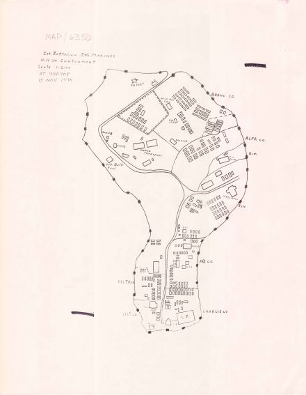
NY-MAP/6350
1st Battalion, 5th Marines Hill 34 Cantonment [Vietnam]
Copy of a map of the Hill 34 cantonment, dated 15 November 1970. Depicts company quarters, chapel, enlisted club, mess hall, and landing zone. Map is situated at coordinates 990708.
|
|
High Resolution TIFF
Unavailable
|
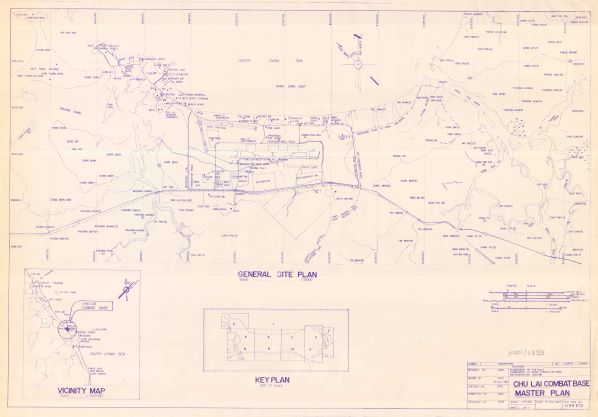
NY-MAP/6353
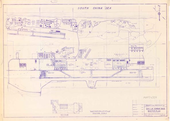
Chu Lai Combat Base Master Plan [Vietnam] [sheet 1 of 11]
A blueprint copy of the Master Plan for the Chu Lai Combat Base (sheet 1 of 11)P-62A), dated 25 November 1967. This large scale map features the base in its entirety, and includes a vicinity map indicating the base's location in Vietnam, as well as a key plan illustrating how the sheets fit togeth to form the smaller scale map.
|
|
High Resolution TIFF
Unavailable
|
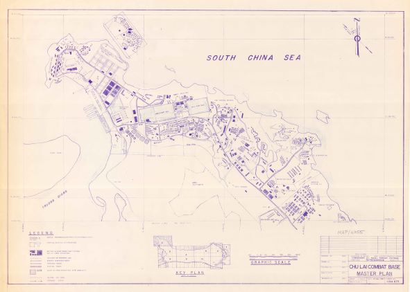
NY-MAP/6355
Chu Lai Combat Base Master Plan [Vietnam] [sheet 2 of 11]
A blueprint copy of the Master Plan for the Chu Lai Combat Base (sheet 2 of 11), dated 27 November 1967. Features include the locations of headquarters for US Army battalions on the eastern edge of the base; the provincial boundary between Quang Tin and Quang Ngai; and roadways.
|
|
High Resolution TIFF
Unavailable
|
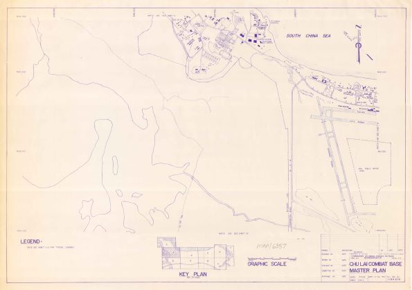
NY-MAP/6357
Chu Lai Combat Base Master Plan [Vietnam] [sheet 3 of 11]
A blueprint copy of the Master Plan for theChu Lai Combat Base (sheet 3 of 11), dated 27 November 1967. Features include Route 1 and perimeter road; runway; and other existing and proposed structures.
|
|
High Resolution TIFF
Unavailable
|
NY-MAP/6359
Chu Lai Combat Base Master Plan [Vietnam] [sheet 4 of 11]
A blueprint copy of the Master Plan for the Chu Lai Combat Base (sheet 4 of 11), dated 27 November 1967. Features include airfield, runway, MAG-12 and MAG-13 aprons and cantonments, existing and proposed roadways.
|
|
High Resolution TIFF
Unavailable
|
NY-MAP/6361
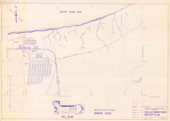
Chu Lai Combat Base Master Plan [Vietnam] [sheet 5 of 11]
A blueprint copy of the Master Plan for the Chu Lai Combat Base (sheet 5 of 11), dated 27 November 1967. Features include 161 Aviation Battalion, 14 Aviation Battalion cantonment, segregated storage areas, and a proposed roadway to Song Tra Bong.
|
|

High Resolution TIFF
Unavailable
|
NY-MAP/6363
Chu Lai Combat Base Master Plan [Vietnam] [sheet 6 of 11]
A blueprint copy of the Master Plan for the Chu Lai Combat Base (sheet 6 of 11), dated 27 November 1967. Features include proposed roadways, the Song Tra Bong river, and other other waterways.
|
|
High Resolution TIFF
Unavailable
|
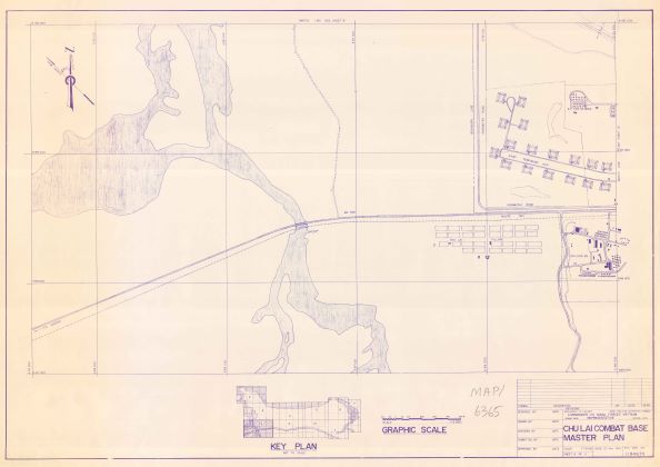
NY-MAP/6365
Chu Lai Combat Base Master Plan [Vietnam] [sheet 8 of 11]
A blueprint copy of the Master Plan for the Chu Lai Combat Base (sheet 8 of 11), dated 27 November 1967. Features include Route 1 and perimeter roads; 9th Engineer Battalion, and the village of Chu Lai.
|
|
High Resolution TIFF
Unavailable
|
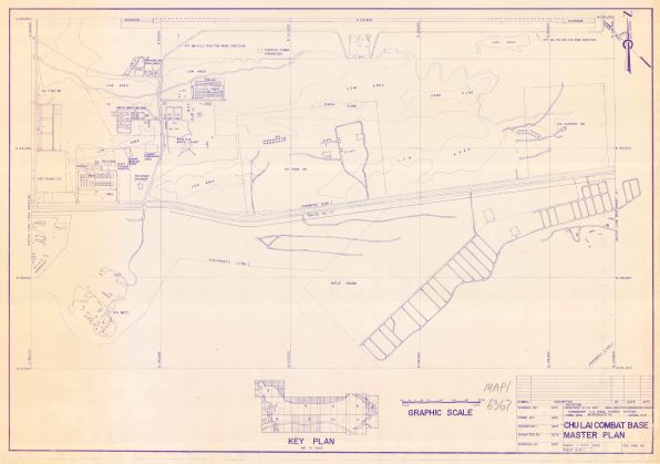
NY-MAP/6367
Chu Lai Combat Base Master Plan [Vietnam] [sheet 9 of 11]
A blueprint copy of the Master Plan for the Chu Lai Combat Base (sheet 9 of 11), dated 27 November 1967. Features include Route 1 and perimeter road; MAC V civilian hospital; the rifle range; 188th Maintenance Battalion cantonment; 163 Transportation Company; sewage treatment plant; laundry facilities; and parking areas.
|
|
High Resolution TIFF
Unavailable
|
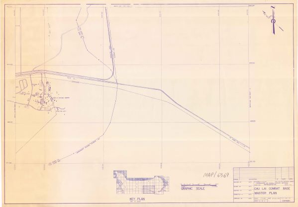
NY-MAP/6369
Chu Lai Combat Base Master Plan [Vietnam] [sheet 10 of 11]
A blueprint copy of the Master Plan for the Chu Lai Combat Base (sheet 10 of 11), dated 27 November 1967. Features include Route 1; 175 Engineer Battalion; 198th Light Infantry Brigade Headquarters; and the boundary line between Quang Tin and Quang Ngai provinces.
|
|
High Resolution TIFF
Unavailable
|
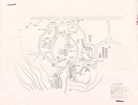
NY-MAP/6346
Compound at 3rd Battalion, 1st Marines [Vietnam]
Copy of a map of the 3d Battalion, 1st Marines compound, June 1970. Depicts company quarters, chapel, enlisted club, firing locations, mess hall, numbered buildings, and landing zone. Map is situated at coordinates 948781. There are 2 copies of this map in the collection.
|
|
High Resolution TIFF
Unavailable
|
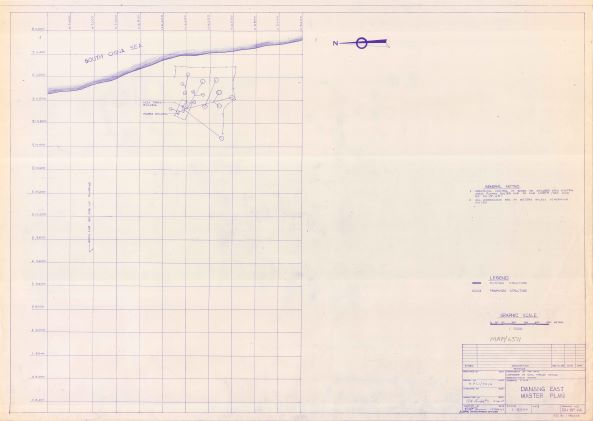
NY-MAP/6371
Danang East Master Plan [Vietnam] [DN-BP-64]
A blueprint copy of a portion of the Master Plan for the Danang East (BP-64), dated 15 December 1967. Features include proposed buildings, including the NSA Trans Building and the Power Building.
|
|
High Resolution TIFF
Unavailable
|
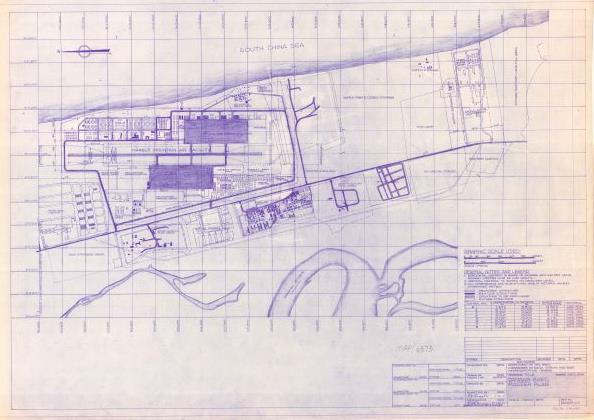
NY-MAP/6373
Danang East Master Plan [Vietnam] [DN-BP-65]
A blueprint copy of a portion of the Master Plan for the Danang East (BP-65), dated 15 December 1967. Features include Marble Mountain Air Facility, Camp Faulkner, POW camp, Special Forces camps, landfill, and roadways.
|
|
High Resolution TIFF
Unavailable
|
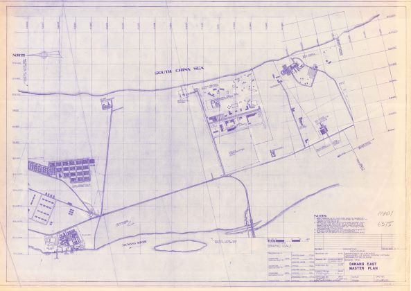
NY-MAP/6375
Danang East Master Plan [Vietnam] [DN-BP-66]
A blueprint copy of a portion of the Master Plan for the Danang East (BP-66), dated 15 December 1967. Features include III MAF commanding general's quarters; officer's club; II MAF headquarters; US Army 1st Logistic Command; 5th Communication Battalion; the China Beach recreation center; and roadways.
|
|
High Resolution TIFF
Unavailable
|
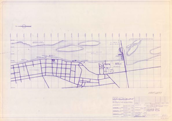
NY-MAP/6377
Danang East Master Plan [Vietnam] [DN-BP-67]
A blueprint copy of a portion of the Master Plan for the Danang East (BP-67), dated 15 December 1967. Features include bridges, piers, and ramps along the Danang River; the city of Danang; and roadways.
|
|
High Resolution TIFF
Unavailable
|
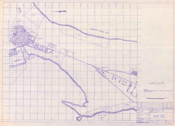
NY-MAP/6379
Danang East Master Plan [Vietnam] [DN-BP-68]
A blueprint copy of a portion of the Master Plan for the Danang East (BP-68), dated 15 December 1967. Features include locations of Vietnamese villages; Camp Tien-Sha; ARVN camp; and roadways.
|
|
High Resolution TIFF
Unavailable
|
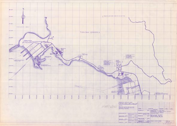
NY-MAP/6381
Danang East Master Plan [Vietnam] [DN-BP-69]
A blueprint copy of a portion of the Master Plan for the Danang East (BP-69), dated 15 December 1967. Features include piers and harbor; Danang Bay; Tien-Sha peninsula; 3d Shore Party Battalion camp; RVN Navy observation island; harbor entrance command post; waterways and roadways.
|
|
High Resolution TIFF
Unavailable
|
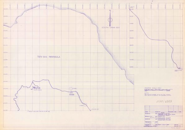
NY-MAP/6383
Danang East Master Plan [Vietnam] [DN-BP-70]
A blueprint copy of a portion of the Master Plan for the Danang East (BP-70), dated 15 December 1967. Features the Tien-Sha peninsula.
|
|
High Resolution TIFF
Unavailable
|
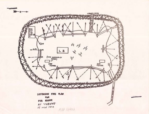
NY-MAP/6340
Defensive Fire Plan for Fire Support Base Ryder [Vietnam]
Copy of a map of the defensive fire plan for FSB Ryder, dated November 1970. Depicts the location and configuration of barbed wire and firing positions. Also depicts buildings within the compound. Map is situated at coordinates 948345. There are 2 copies of this map in the collection.
|
|
High Resolution TIFF
Unavailable
|
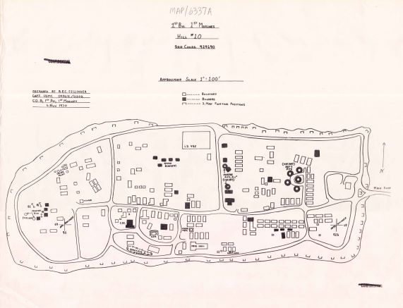
NY-MAP/6337
Hill 10, 1st Battalion, 1st Marines [Vietnam]
Copy of a map of the fire base on Hill 10, dated November 1970. Depicts the location and configuration of barbed wire and firing positions. Also depicts buildings within the compound. Map is situated at coordinates 924690. There are 2 copies of this map in the collection.
|
|
High Resolution TIFF
Unavailable
|
NY-MAP/2157
Khe Sanh [Vietnam]
An annotated map depicting firebases and command posts at Khe Sanh.
|
|
High Resolution TIFF
Unavailable
|
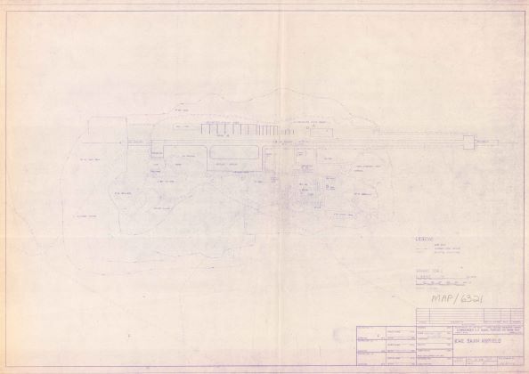
NY-MAP/6321
Khe Sanh Airfield [Vietnam]
A blueprint copy of the Khe Sanh airfield, dated 26 August 1967. This map depicts the airfield in its entirety.
|
|

High Resolution TIFF
Unavailable
|
NY-MAP/6391
Master Plan: Dong Ha Forward Combat Base [Vietnam]
A blueprint copy of the Master Plan for the Dong Ha Forward Combat Base, dated 5 December 1967. This large scale map features the base in its entirety, and includes a vicinity map indicating the airfields's location in Vietnam. Features include Marine and US Army facilities.
|
|

High Resolution TIFF
Unavailable
|
NY-MAP/6395
Master: Port Facilities, Tan My [Vietnam]
A blueprint copy of the Master Plan for the port facilities at Tan My, dated 6 December 1967. This map features the base in its entirety (including an index of buildings); and a vicinity map indicating the base's location in Vietnam.
|
|
High Resolution TIFF
Unavailable
|
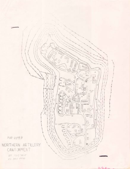
NY-MAP/6344
Northern Artillery Cantonment [Vietnam]
Copy of a map of the northern artillery cantonment, dated November 1970. Depicts the location and configuration of barbed wire, the Headquarters of 1st Battalion, 11th Marines, landing zones, mess hall, motor pool, and other buildings within the compound. Map is situated at coordinates 923795. There are 2 copies of this map in the collection.
|
|
High Resolution TIFF
Unavailable
|
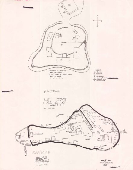
NY-MAP/6349
Outpost Reno [Vietnam] and Hill 270 [Vietnam]
Copy of two maps: Outpost Reno fire base, located at coordinates 884746 and dated 15 November 1970; and Hill 237 , 1st Battalion, 1st Marines, located at 865661. Both show ammunition bunkers, trench lines, and gun positions. There are 2 copies of this map in the collection.
|
|
High Resolution TIFF
Unavailable
|
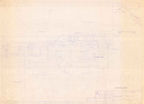
NY-MAP/6389
Quang Tri Airfield Master Plan [Vietnam]
A blueprint copy of the Master Plan for the Quang Tri airfield, dated 5 December 1967. This large scale map features the base in its entirety, and includes a location siting plan indicating the airfields's location in Vietnam. Features include the Marine Air Control Squadron building; runways; the control tower; storage areas; hangars; helicopter landing pads; and other buildings.
|